Leverage Geographic Information System Labs to boost governance
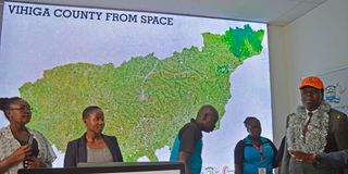
Then-Devolution CS and ASALS Eugene Wamalwa (right) at the launch of the Directorate of Geospatial Technologies Services (GTS) Lab at Vihiga County Headquarters on May 16, 2019. Also known as the Geographic Information System (GIS) the data analytics system will be applied in rational decision-making to spur development in the devolved unit.

Kenya has made a notable shift towards digital transformation, particularly in the realm of governance. Significant in this direction is the establishment of Geographic Information System (GIS) Labs in 29 of the 47 county governments.
The monumental initiative is facilitated by the UN’s Food and Agriculture Organization (FAO) in collaboration with the Ministry of Lands, National Land Commission and the Council of Governors.
This endeavour underscores the pivotal role of technology in fostering efficient land governance, sustainable development and inclusive growth.


GIS offers a robust platform for managing, analysing and visualising spatial data, revolutionising the way governments interact with their land resources. The significance of labs cannot be overstated in a country where land issues are intricately linked: Factor of production, food security, livelihoods and overall economic prosperity.
First, GIS implementation streamlines public reporting mechanisms, saving both time and resources. By centralising relevant data into a comprehensive system, citizens gain easy access to crucial information. That empowers individuals to make informed decisions, fostering transparency and accountability in governance structures.
GIS Labs enhance public engagement by soliciting feedback from citizens and residents. Inclusive governance necessitates active participation from all stakeholders, and GIS technology provides a platform for meaningful dialogue between government agencies and the communities they serve.
GIS is pivotal in optimising crime prevention and emergency management strategies. By mapping crime hotspots, emergency response routes and critical infrastructure, law enforcement agencies can devise targeted interventions for public safety.
The labs also have far-reaching implications for urban planning and zoning. By leveraging spatial data analysis, county governments can identify suitable locations for infrastructure development, urban expansion and environmental preservation. In essence, they herald an era of digital governance marked by transparency, efficiency and citizen-centricity. But the successful integration of GIS technology hinges on adequate funding, robust institutional frameworks, capacity-building initiatives, political goodwill, progressive thinking and changed oriented staff and multi-stakeholder collaboration.
County governments must prioritise investment in digital infrastructure, human capital development and stakeholder engagement to harness the potential of GIS in advancing socioeconomic development agendas. That can unlock new pathways to inclusive growth, environmental sustainability and equitable development, ultimately paving the way for a prosperous future for all citizens.
As Mandera County becomes the latest beneficiary of GIS Lab support from FAO, it is imperative that other county governments follow suit, embracing technology as a catalyst for transformative change.
- Mr Alio is the CECM for Lands in the Mandera County government. [email protected].