Why Baringo’s landslides spell imminent danger for residents
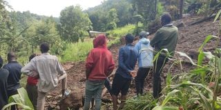
Locals mill around an area cut off by a landslide that occurred at Kapkombe village, Baringo North on August 6, killing more than five people and destroying property. The twin landslides occurred in Kapchebogel and Kapkombe villages. Photo- Florah Koech

What you need to know:
- Environmentalists and geologists in the area have raised concerns about the safety of locals living in areas vulnerable to landslides.
- Prof Simon Onywere, a spatial environmental planner, geologist and an associate Professor at Kenyatta University indicates that most of the hilly parts in the country are volcanic and have been weathered, from rocks to soil, thus fragile
On the night of August 6, a few minutes past 9 pm, heavy rains that lasted more than four hours hit Kapchebogel and Kapkombe villages in Baringo North, just when most locals had retired to bed after their evening meal.
As the rain drummed gently on the iron sheets and soaked the ground, it seemed like an ordinary downpour. Many residents went to bed, grateful for the blessing of the rain.
Hours into the night, a loud bang jolted the residents from their sleep. “I woke up in panic and I could hear some wailing from a distance,” one resident said.
When the rains finally ceased, the locals were confronted with the devastation left behind. Massive boulders uprooted trees, and dozens of houses had been swept downstream.
Tragically, the occupants of those homes were also caught in the debris, buried beneath the wreckage.
That night, Zakayo Ruto, 48, from Kapchebogel village suffered an unimaginable loss. He lost four members of his family—his wife, 38-year-old Gladys Chepkangor, his two sons, 11-year-old Evans Katamei and Jonathan Katamei, and his 16-year-old nephew, Hillary Kabutiei.
Their four-roomed house, a kitchen and a store had been flattened and reduced to a mere field.
His late father’s house where the two teenage boys had been sleeping, was not spared either in the destruction. The once-thriving crops around their compound were destroyed, their stems and leaves shredded into pieces and scattered haphazardly across the ground.
In the neighbouring Kapkombe village, a middle-aged woman's house was also swept away by the landslide. She was not spared.
However, despite the calamity, locals in the area claim it is the only place they know as their home, and they have nowhere else to go. In the aftermath of the landslides, some locals whose houses were near the cut-off land were still adamant about leaving or seeking refuge in a safer place.
A spot check by Climate Action revealed a grim picture of how the locals were living—houses erected on steep slopes, waterways and along riparian areas.
The roads to the said villages have also been cut off, while some have fissures, an indication that it is a ticking time bomb in case the heavy rains persist.
“This is where I have known as my home for nearly five decades. My grandfather and my parents, who gave us a portion of their land, also lived here. I have nowhere else to go unless the government gives me an alternative parcel of land,” says Mr Ruto who is squatting at Kasisit Primary School with three of his remaining children and 35 other families also affected by the landslides.
The father of five reflects that in the 1980s, another landslide hit the area, cutting off close to two kilometres of land but no one fled the area because no houses or people were affected during the incident.
Their forefathers, he said, lived in Keremol Forest, the present-day Saimo, which is a flat land before they were moved by the then government to allow for the conservation of the forest, with a promise that they would be given an alternative land, a promise he says was not honoured.
“Disgruntled, they resorted to go and live down the slopes of the forest where we live now, though it is not good for habitation because it is steep. Building a house here, let alone farming is not a walk in the park because you have to create terraces along the sloppy area to get a flat land. We have been forced to live here, the challenges notwithstanding,” shares Ruto.
He however said despite the area being risky, no government official has ever informed them to relocate.
“After losing four of my family members to the recent landslides, I have vowed never to live in my village again. I will only go and bury my deceased kin because we have nowhere else to inter them, then I just squat at the primary school where we have sought refuge. We appeal to the state to consider our plight and give us an alternative land, just as they promised our forefathers so that we can live like other Kenyans,” he remarks.
Faith Jemutai, another resident, says that they have lived in the sloppy area for decades and cannot move because they have no other place to go.
“This is where we call home. We have built our houses along the slopes because we have no other choice. This area is prone to landslides and we are told that several houses were swept here in the 1960s, but locals resettled again,” Shares Ms Jemutai.
Environmentalists and geologists in the area have raised concerns about the safety of locals living in areas vulnerable to landslides.
Raphael Kimosop, an environmentalist who works as the Baringo County catchment and wetlands officer, indicated that the area has received above-normal rainfall for the past eight months.
He said the region normally receives long rains between March and May and from October to December.
“The long rains experienced in Baringo are abnormal. We normally receive rain from March to May and from October to December, but we are now in August and it is still raining. The rains have been above normal and the water took time to percolate so the retention time for runoff is reduced. Whenever it rains, the soil absorbs the water and it becomes saturated,” says Mr Kimosop.
“For those living in steep topography, for instance, an inclination of 45 degrees, when the water uphill percolates into the ground and becomes saturated, the surface of the earth becomes heavy burdened by the added weight of trees, stones and mud. When that pressure is exerted, the soil tries to release it and in the process, people living in the sloppy areas become victims of the situation because when soil becomes muddy, it becomes weak and breaks in the form of a landslide,” offers the geologist.
He urges the county government to implement sensitisation programs, advising people living in the steep areas to relocate to safer grounds during the rainy season.
“There is a need for them to move to flat areas or higher areas which are not prone to such disasters. Supposing earthquakes or small earth tremors are experienced in such areas, they are vulnerable to such unfortunate calamities,” notes the environmentalist.
He also emphasized that devolved units should be cognizant of land surveys and allocation of land to people, ensuring that steep, sloped areas are marked as uninhabitable.
“In this case, we will not have a case where people are allocated “bad lands”. We also need to have sustainable land management where people are taught how to use their land because in this case, people in the steep areas are using very remote ways of farming, where they are living in the same land and farming, to an extent of cultivating along the contours. The 'fanya juu' terraces kind of farming is not working anymore,” he told Climate Action.
He also suggests that geologists are involved to first determine the soil type and then assess the rock formations. This would help ascertain the soil's permeability and its capacity to retain water at any given time.
Prof Simon Onywere, a spatial environmental planner, geologist and an associate Professor at Kenyatta University indicates that most of the hilly parts in the country are volcanic and have been weathered, from rocks to soil, thus fragile.
“In this case, water is flowing from the soil above, onto the open surface of the rock because it cannot penetrate inside it. If the weight of the soil above has received water, it will creep, shear and flow at the influence of gravity and it can collapse, resulting in a landslide,” says Prof Onywere.
Landslides, he says, mainly occur because unconsolidated material becomes heavier because of infiltration with water.
“If you look at Cherangany or Tugen Hills, you will see that much of the land is loose and tends to collapse every time it rains. This means if your house is near the valley, it might be swept along,” says the geologist.
According to Prof Onywere, land use is still a challenge in the rural setting and a key contributor to such calamities. “Who controls how land is being used? Should it be left to the communities to find their means of occupying and using it or should it be controlled? The institutions that are supposed to map or control it have not done so,” he argues.