Weatherman breaks down phenomenon that causes July rains
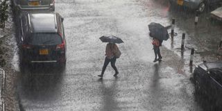
Heavy rains that pounded Nairobi on July 9, 2024. Kenyans have been wondering why it has been raining heavily in parts of the country this month.

What you need to know:
- As per the patterns we are observing, there is a possibility of Kenya experiencing La Niña.
- La Niña means 'little girl' in Spanish and it has the opposite effect of El Niño.
- During La Niña events, trade winds are even stronger than usual, pushing more warm water toward Asia.
Kenyans have been wondering why it has been raining heavily in parts of the country this month.
Although the rain has prompted a lot of speculation, the weatherman says there is nothing unusual about it. Speaking to Climate Action, Dr David Gikungu, the Kenya Meteorological Department director, described the current rainfall as a 'characteristic of July'.
"We are out of El Nino. What is happening is that the system we refer to as Inter Tropical Convergence Zone (ITCZ) is still with us and is more pronounced in the western parts of the region, including Congo, Uganda, among others," he said.
The meteorologist explained that when the northeast trade winds from the northern hemisphere and the southeast winds from the southern hemisphere come together, they force air up into the atmosphere, forming the ITCZ. This leads to the development of frequent thunderstorms and heavy rain.
ITCZ appears as a band of clouds consisting of showers and occasional thunderstorms that encircle the globe near the equator.
According to the National Oceanic and Atmospheric Administration, convective storms in the tropics tend to be short-lived and usually small-scale, though they can produce intense rainfall.
It is estimated that 40 per cent of all tropical rainfall rates exceed one inch per hour.
"It's characteristic of the season that starts in March ending in May and sometimes gets into June and July," he highlighted.
The weatherman told Climate Action that the position of the ITCZ varies with the seasons and lags behind the sun's relative position above the earth's surface by about one to two months.
It generally correlates to the thermal equator.
Because water has a higher heat capacity than land (the ocean heats up more slowly than the land), the ITCZ propagates poleward more prominently over land than over water and over the northern hemisphere than over the southern hemisphere.
"In July and August, over the Atlantic and Pacific, the ITCZ is between five and 15 degrees north of the Equator, but further north over the land masses of Africa and Asia", Dr Gikungu noted.
The KMD director, however, reminded that ITCZ being more pronounced in the western parts of the region such as Congo and Uganda is not standard as it fluctuates depending on the strength of the ocean winds.
"Sometimes it may result in rain away from the west - places like the Rift Valley's east highlands, including Nairobi. For example, the winds on the coast have been very strong at the moment; it's just that the winds blow away from the coast, hence no rain," Dr Gikungu said.
"As per the patterns we are observing, there is a possibility of Kenya experiencing La Niña," he disclosed.
La Niña means 'little girl' in Spanish and it has the opposite effect of El Niño.
During La Niña events, trade winds are even stronger than usual, pushing more warm water toward Asia.
In Kenya, La Niña brings about dry conditions during the short rainy season from October and was largely blamed for the multi-year drought that the country experienced between 2020 and 2023.
In February this year, the National Weather Service's Climate Prediction Center (CPC) predicted that La Niña would occur after El Nino.
"Even though forecasts made through the spring season tend to be less reliable, there is a historical tendency for La Nina to follow strong El Nino events," CPC said.
La Nina is, however, beneficial to India as its development is good for the Indian monsoon; hence abundant rainfall in the Asian sub-continent.
"Next month, KMD will be holding a conference resulting from a workshop where we looked at models and what they are talking about so that we are able to advise the nation and the region in general on the way forward," Dr Gikungu said.
"We associate El Nino with very heavy rainfall yet there are other places that associate El Nino with drought," the KMD.