So much huff and puff about El Nino. What is it?
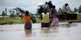
Residents of Ombeyi Village in Ahero are on the move to safer grounds after their houses were flooded by the heavy El Nino rains on 17th November 2015.
What you need to know:
- El Nino is the positive phase of the El Nino Southern Oscillation (ENSO) phenomena.
- ENSO has three phases; positive (El Nino); Neutral; and the Negative (La Nina) phase.
- El Niño events are common and typically occur every three to five years
The October to December rainy season is here with us and forecasts have indicated a possibility of experiencing wetter than usual rainfall season over the Eastern Africa region. One of the major drivers attributed to this is the El Nino, which is the positive phase of the El Nino Southern Oscillation (ENSO) phenomena. ENSO has three phases; positive (El Nino); Neutral; and the Negative (La Nina) phase. Remember that over the past years (2020-2022) we witnessed the negative phase of ENSO (La Nina) that led to depressed rainfall (drought) over the region.
Basically, El Nino is a condition that occurs when the sea surface temperatures become unusually warm in the central and eastern Pacific Ocean and unusually cooler in the western part of the Pacific Ocean. This creates a kind of seesaw effect, leading to a warm pool of water and an unstable atmosphere, resulting in increased rainfall in its vicinity. The seesaw effect usually has an influence on global climate through a process usually termed by climate scientists as “teleconnections”. As a result, increased rainfall is often experienced over eastern Africa during the October to December rainfall season. Although El Nino is mostly associated with increased rainfall over eastern Africa, it is not a synonym for ‘too much rainfall’ as some areas experience dry condition.
However, it is crucial to recognise that apart from El Niño, other climatic phenomena such as the Indian Ocean Dipole (IOD), also known as the ‘Indian Nino,’ exert a significant influence on Eastern Africa, ultimately shaping the magnitude of El Niño’s impact on the region’s climate. When the IOD exhibits a positive phase (with sea surface temperatures near the Eastern African coast warmer than those to the east, near the southern part of Indonesia), and El Niño conditions are present, it sets the stage for increased rainfall in our region. This is precisely the scenario we are currently witnessing. Additionally, it is worth noting that El Niño events are common and typically occur every three to five years, but the extent of their impact in terms of rainfall varies from year to year, depending on the prevailing phase of the Indian Ocean Dipole (IOD).In certain instances, such as the notorious El Niño event of 1997, the outcome was an overwhelming deluge across most Eastern African regions. The 1997 El Niño event remains etched in memory as one of the most catastrophic, and the mention of El Nino is now causing a scare to many people. The enhanced rainfall it brought about triggered extensive flooding in many parts of Eastern Africa. The torrential and sustained downpours led to flash floods, riverine inundations and even deadly landslides.
Agricultural fields suffered immense damage, resulting in crop losses both in the fields and in store, leading to post-harvest losses. A significant number of livestock perished as well. Infrastructure, including roads, communication networks and bridges, bore the brunt of the excess rains. Conversely, in other years like 2015, despite the relatively large magnitude of El Niño, only select areas experienced increased rainfall due to the weak Indian Ocean Dipole . Since 1997, we’ve encountered seven El Niño events, with some spanning multiple years.
In preparation for the anticipated El Niño rains in the upcoming October to December season, it is imperative for the region to put in measures for proactive response. This underscores the critical need for collaborative efforts among governments and humanitarian organisations. An example of this preparedness is the pre-emptive relocation of residents residing in flood-prone areas, a task that should be completed well in advance of the onset of heavy rains.
Additionally, there should be a strategic prepositioning of essential supplies including medical resources, food provisions and non-food items to assist those expected to be displaced by flooding. It is also essential to empower communities with the knowledge and skills necessary to respond effectively to extreme weather events. This ensures that households are well-prepared to navigate life-threatening situations they may encounter.
. As the season draws near, we should increase preparedness and reduce scare and alarmist information that can cause more harm than good!
Eunice is a climate modelling expert with contributions from ICPAC technical team


