Sentinel hub timelapse captured in April 2020 shows flooding of River Nzoia in Budalangi.
| Via Sentinel HubHealth
Premium
Satellite imagery uncovers the scale of Kenya's floods

For a long time, Kenya has been facing a series of devastating floods triggered by heavy rains that have been attributed to climate change, and now there are even more growing concerns after the El-Nino announcement was made. This will mean more prolonged rainfall and intense floods which could worsen the already dire situation of the flood-prone communities.
The floods have displaced hundreds of thousands of people, destroyed crops and infrastructure, and threatened lives and livelihoods.
But how can we assess the extent of the damage and the impact of the recurring floods on the affected communities?


The Nation analysed photos and videos shared on social media by Kenyan flood victims, using geolocation data and timestamps to identify the locations of the social media posts, while comparing them with the satellite images taken before and after the floods.
Some of the most devastating damage can be seen along Budalang’i, Lower Gucha along River Migori basin, Lake Baringo basin, Nyando River Basin and Isiolo.
The Nyando River Basin
This region covers parts of Kisumu, Kericho, Nandi and Nyando counties. It is prone to flooding due to its low-lying topography, poor drainage, and high rainfall intensity.
In April 2020, the Nyando River Basin in Kisumu County was hit by severe floods, following heavy rains that caused the river to burst its banks. The floods submerged homes, schools, crops and infrastructure, displacing more than 13,300 people in Nyando Sub County. The affected areas included Ahero, Nyamaso, Kokala, Nyakach and Murononi. The floods also posed a threat to food security and health in the region.
An X user complained about the perennial floods that had been given little consideration by the authorities.

A geolocation of River Nyando flooding in April 2020.
We found out the exact location for this video showing how much the rising water levels had isolated some areas and halted transport services on the major road between Kisumu and Kericho.
In the Nyando River Basin, we established that over 420 square kilometres had been ruined by the floods. The satellite images showed that the river had flooded parts of Kisumu and Nyando counties, affecting several towns and villages, including Ahero and Awasi.

An approximated landmass of 420 square Kilometers was affected by River Nyando Floods in April 2020.
Budalang’i
Budalang’i is a low-lying area in Busia County, located on the shores of Lake Victoria. This area is prone to flooding, which has resulted in many deaths and displacements over the years.

Sentinel hub timelapse captured in April 2020 shows flooding in the River Nyando Basin.
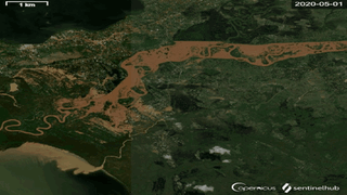
According to reports, Budalang’i has experienced at least five major floods the latest of which was in April 2020, following heavy rains that caused the River Nzoia to burst its banks. The floods submerged homes, crops and infrastructure, displacing more than 40,000 people in the area. The affected villages included Mau Mau, Rukala, Bulwani and Mudimbya.
The floods immensely destroyed homes, crops, infrastructure, and livelihoods of the residents, and posed health and environmental risks.
The floods also caused casualties, with at least one person reported dead and several others injured. During the aftermath of the incident, the MP for Budalang’i, Raphael Wanjala, explained residents were at risk of Covid-19 and cholera outbreaks.

A geolocation of Budalangi flooding in April 2020.
The satellite images from Sentinel Hub, captured between April 1st and April 26th, showed that the River Nzoia had burst its banks and flooded several villages, including Bunyala and Port Victoria. The analysis also found evidence of erosion and sedimentation along the river course.

Sentinel hub timelapse captured in April 2020 shows flooding of River Nzoia in Budalangi.
Backflows

Approximately 2 square Kilometers(marked in red) of land has been gradually replaced by adjacent water body from Lake Victoria.
The floods were attributed to a water backflow from Lake Victoria, which was also affected by high water levels, siltation of rivers that drain into the lake, and poor maintenance of dams and dykes.

A timelapse showing buildings completely submerged in water as a result of the backflow of water from Lake Victoria.
Isiolo
This county is located in the arid and semi-arid lands of northern Kenya. It is prone to flooding due to flash floods from the Ewaso Nyiro River.
Following the April 2023 floods, over 1,120 families were displaced, especially from Irehaboru area and had to be relocated owing to recurrent floods when Ewaso Nyiro River burst banks.
Following the flash floods caused by heavy rains in the highlands, satellite images captured between April 8 and April 19, showed that several seasonal rivers had turned into raging torrents, cutting off roads and bridges.

A geolocation of Isiolo flooding in April 2023.
Lower Gucha along River Migori basin
This region covers parts of Migori and Homa Bay counties. It is prone to flooding due to its location downstream of the Migori River, which receives water from Lake Victoria and other tributaries.
In April 2020, over 1,000 families were affected by the floods in lower Gucha, along the River Migori basin. The highest water levels were reported at 6.10 millimetres, thereby bursting its banks.

Sentinel hub timelapse captured between March and April 2023 shows flooding of Ewaso Nyiro River in Isiolo.
The satellite images captured between May 1st and June 3oth showed that the river had overflowed and still flooded parts of Kuria West and Nyatike sub-counties.

Sentinel hub timelapse captured between May and June 2020 shows flooding on River Migori basin in Migori.
Lake Baringo basin
Lake Baringo, one of the Great Rift Valley lakes in Kenya, has been experiencing unprecedented flooding since 2013, due to heavy rains and climate change. The lake has increased in size by over 40 per cent in the past decade, submerging homes, schools, businesses, farms and wildlife habitats.

ESRI images showing the water volume levels of Lake Baringo in 2014 and 2022.
Subsequently, the floods have displaced more than 30,000 families and destroyed their livelihoods. The bulging lake has also brought crocodiles and hippos closer to human settlements, posing a threat to safety and health. The floods have affected the tourism and fisheries sectors, which are vital sources of income for the local communities.

ESRI images showing the water volume levels of Lake Baringo in 2014 and 2022.
The satellite images showed that the lake had increased in size since 2014. This expansion has led to a surge in water volume, displacing numerous families and submerging homes along its shores.

Satellite image showing buildings along Lake Baringo completely submerged in water: In 2014 vs 2022.
The rising water level has encroached upon the shoreline, engulfing agricultural lands and settlements that were once far from its banks. The displacement of families and the submersion of homes have created significant challenges for the affected communities, leading to the loss of livelihoods and the need for relocation to safer areas.