-
Editions
-
ePaper

Floods: How Winston Churchill failed Nairobi and why we are not any better now
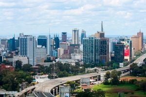
Nairobi City Skyline on April 27, 2023 (inset) Winston Churchill.
By John Kamau
What you need to know:
- The imaginations of railway engineers did not go beyond laying a single track and building a few stores
- The ground on which the town is built is low and swampy.
- The supply of water is indifferent, and the situation is generally unhealthy.
Recently, I stumbled on a 1930 newspaper cutting about the flooding that had hit Nairobi.
The photo was taken on the Government Road (now Moi Avenue), most likely the section between Khoja Mosque and Central Police Station. On it, a lone vehicle is wading through a sheet of water, and the tall blue-gum trees, planted by John Ainsworth in early 1900s, are seen towering above.
The story of Nairobi’s blue-gum trees is well known and were introduced from Machakos, the former capital of Imperial British East Africa, to rid the town of uninhabitable marshy areas and the papyrus weeds where lions always lay in wait. Before the Uganda Railway (U.R.) reached Mile 326 – or what was later christened Nairobi – this was known as a flood plain during the rainy season. When drought struck, early recorders described it as a “desolate, windswept swamp”.
The imaginations of railway engineers did not go beyond laying a single track and building a few stores as they prepared to climb into the highlands.

Motorists drive through a flooded section of Mombasa Road between Bellevue and Nexgen Mall in Nairobi on January 13, 2024
The swamp site and that title would aptly have fitted Nairobi, was picked because it was the last place where railway wagons could quickly turn – the last flat plain. Those wondering why Nairobi, the place of calm waters, is flooding must live with this old hydrological reality – worsened by poor urban planning. We must have forgotten that railway engineer Richard Owen Preston had described Mile 326 (Nairobi) as “a bleak, swampy stretch of soppy landscape, windswept, devoid of human habitation of any sort, the resort of thousands of wild animals of every species”. Perhaps there was a reason that no human beings occupied the Nairobi site. As Elspeth Huxley aptly pointed out in her book White Man’s Country, Nairobi was a place of frogs.
She wrote that beyond its single street “lay the swamp where frogs lived every night. At dusk, they used to bark out their vibrant chorus and spread a cloak of deep, incessant sound over the little township”. I have written on this before.
There was an attempt to remove the town from the plains. The fear was that a city was emerging in a poorly drained section of the Protectorate. However, a row between Ainsworth and the railway engineers failed to resolve this issue. London also seemed to care so much about Nairobi, and the feeling was that no city could emerge without mineral potential. Finally, when the Secretary of State for the Colonies, Winston Churchill, visited Kenya in 1907 and was asked to decide, he left Nairobi to its fate. In his book, My African Journey, Churchill wrote of Nairobi. “Originally chosen as a convenient place for assembling the extensive depots and shops necessary to the construction and maintenance of the railway, it enjoys no advantages as a residential site. The ground on which the town is built is low and swampy. The supply of water is indifferent, and the situation is generally unhealthy.
Government buildings
A mile farther on, however, upon the rising ground, a finer position could have been found, and this quarter is already being occupied sparsely by Government buildings, hospitals, and barracks.
It is now too late to change, and thus, lack of foresight and of a comprehensive view leaves its permanent imprint upon the countenance of a new country.” Churchill had previously been informed of the Nairobi problem by Sir James Sadler, commissioner for the Protectorate, that Uganda Railway engineers had selected the site without consulting medical or sanitary authorities.

Motorists drive through a flooded section of Lower Hill Road at the junction of Haile Sellasie Avenue as heavy rains hit the city.
He was informed that Nairobi had “inadequate drainage, unsuitable for a large and growing population. (It is a) depression with a very thin layer of soil or rock. The soil was water-logged during the greater part of the year.” Finally, he observed a problem that would later haunt Nairobians: “… when the rainy season commenced, the whole town is practically transformed into a swamp.” Churchill failed to make a decision, and we now live with a “lack of foresight”, as Churchill put it – and we have made it worse by blocking the water exits. In his book, Inside Africa, John Gunter says Nairobi became a capital “by accident. A better location for the capital, and the one first planned, was Limuru, twenty-eight miles further upcountry, and at a higher elevation.”
In Nairobi and other environs, we are witnessing overwhelming water deterioration or inadequate infrastructure.
And this deterioration is not only in impoverished, neglected, and socioeconomically isolated urban communities but also in the leafy suburbs. I think the time has come for Nema (The National Environment Management Authority) to mark properties in potential floodplains so that current and future buyers are not duped. The water has clearly mapped residence areas and those requiring immediate intervention. The same can be said of Mai Mahiu, which sits within a disaster zone. How we live with these two facts will inform the future and how we mitigate such disasters. Small streams have turned lethal rivers.
If you look at its volcanic ashes and the hot springs that give the town its name, you will realise it sits on top of active magma chambers or some geothermal reservoir. Until recently, those slopes of Mai Mahiu were uninhabited for apparent reasons.
They were dangerous. Mai Mahiu has also been the site of studies after fissures occurred within that area.
Railway engineers
For thousands of years, the region’s volcanic ashes from Mt Longonot have created an unstable topography. A downfall offers an opportunity for landslides or mass movement of materials. With that knowledge, it would be advisable to stay away from the potential calamities of geography. I was reading MF Hill’s Permanent Way to understand how engineers tried to overcome these flooding predicaments. Hill recalls an incident in 1919 when floods between Kijabe and Naivasha washed away the railway line between Fort Ternan and Kisumu. The railway engineers had to work out a formula for dealing with the floods. A decision had to be made early to use steel sleepers for the railway, for wood would easily float or be eaten by white ants. I will use the building of the railway and the lessons that the engineers learnt, and I hope this can inform how we look at our infrastructure.

A flooded section of Mombasa Road between Bellevue and Nexgen Mall on January 13, 2024.
With each flood, the railway engineers would rectify the situation.
As Hill wrote about the section within the Taru desert: “Exceedingly heavy rains proved that the original provision for bridges and culverts had been quite inadequate, and much additional work had to be undertaken to cope with the need for increased waterways.”
What that means, as we examine the flooding in various parts of the country, is that we have an opportunity to map water paths and build permanent works. After the railway had passed through the Kapiti and Athi Plains, the engineers initially thought they had successfully laid a perfect line.
They were wrong.
“From January to April 1900, the rain fell almost continuously, and no dry season heralded the new century. The heavy black cotton soil between Miles 280 and Miles 323, became a quagmire. The earthworks lost their form and the unballasted line became impassable for trains for nearly a month.” “In March (1919) there were more serious wash-aways between Kibwezi and Simba, which caused suspension of all traffic for several days.” Watching rivers overflow some of Nairobi’s bridges reminds us to deepen the trenches to accommodate more water or raise the bridges. But more so, we must have discipline in urban planning. The rains have exposed our planning inadequacy and the shortcuts that we have taken.
Winston Churchill failed Nairobi, but we have not done any better.


