A fisherman paddles a traditional raft past one of the submerged buildings of Soi Lodge on the shores of Lake Baringo, where rising water levels have seen the lake surface area expand
| AFPNews
Premium
The culprits behind rising water levels in Rift lakes

Rising water levels in the Rift Valley lakes, the Turkwel Gorge Dam and Lake Victoria have been the subject of debate for several years, with people drowning and thousands of homes and other structures submerged in ruin.
The waters in lakes Nakuru, Baringo, Bogoria, Naivasha, Turkana, Logipi and Elementaita, the Turkwel Dam and others have risen dramatically over the years, submerging adjacent structures like schools, hospitals, homes, churches and hotels.
The Kenyan government and the United Nations Development Programme (UNDP) studied the phenomenon over the past year and released the results in November.


The research showed that rising water levels had generated a humanitarian crisis, with about 75,987 households in 13 affected counties and 379,935 people requiring urgent assistance after being displaced from their homes.
The report cited three factors: climate change, siltation caused by human activities and geological and tectonic activities.
Climate change was recorded as the main reason for the rising water levels, indicating that changes in land use practices have led to increased runoff, causing larger volumes of water to flow directly and rapidly from the land surface into the lakes.
Greater inflow of fresh water into some of the lakes has destabilised their already fragile ecology, harming the resilience and distribution of certain water species.
The report cites human activities as a threat to freshwater ecosystems – mainly deforestation and excessive drawing of water from lakes, rivers, wetland systems and groundwater.
Kenya receives long rains from March to May and short rains from October to December. January and February are usually hot and dry while the June to August period is cool and dry, even though it is becoming one of the rainy seasons in Western Kenya due to climate change.
In 2019, Kenya generally received higher rainfall than the long-term mean, with the October-December season experiencing some of the highest downpours ever recorded, comparable only to 1961 and 1997.
Land degradation was also cited as one of the causes of flooding, owing to reduced forest cover in water towers, including Mt Kenya, the Aberdare ranges, the Mau Complex, Mt Elgon and the Cherangany Hills.
“This has contributed to the disruption of the hydrological cycle and to soil erosion that is one of the major causes of the happenings in all the lakes,” the report says.
“Some of the factors that have contributed to the changes in land use observed across the water basins (are) increased population, urbanisation, intensified agricultural activities, and poor management of forests, which has increased precipitation in the rainy seasons and ensures permanent flow of rivers during the dry seasons.”

A crocodile basks atop a submerged house in Loruk, Baringo County. Kenya’s Rift Valley lakes have received global attention due to rising water levels, which have displaced thousands of people and pushed communities further inland to new homes as climate change refugees.
Geological and tectonic movements were also blamed for the exponential rise in water levels in Rift Valley lakes since 2010.
A significant increase in lake water levels was recorded in 1901, 1963 and since 2013, the report shows.
The Rift Valley system hosts several lake basins of varying sizes whose environments are largely influenced by tectonic, volcanic and climate-driven processes.
During past extreme wet periods, the water levels in the lakes were high, and all basins evolved towards freshwater systems.
For instance, the terraces observed above lakes Nakuru, Naivasha and Elementeita reveal strandlines of the Great Gamblian Lake that was once covered by water in the early Holocene period (between about 12,000 and 7,000 years ago) .
This was later affected by magmatic activities like the Eburru massif that led to the segmentation of the original lake into three sub-basins.
“Since the East African region is an active tectonic belt characterised by extensional stress-regime, it is anticipated that a myriad of tectonic forces continue to shape the present rift geometry including the segmentation of rift lake basins,” the report says.
Because the lakes are located in an active tectonic belt where open faults and fractures continue to dispel significant amounts of gases like carbon dioxide, the likelihood of high gas concentrations in the water bodies raises major safety concerns.
This is likely to happen, considering that some of the submerged geysers at Lake Bogoria could potentially lead to gas saturation, a phenomenon that could be replicated in other Rift Valley lakes.
Besides human activities, the report says, tectonic activities also influence drainage networks and catchment hydrology.
“All the lakes in the rift are considered to have significant components of underground recharge and discharge including lakes Naivasha, Magadi, Bogoria and Baringo, which have no known surface outflow channels, yet they remain relatively fresh in spite of high evapotranspiration,” the report says.
The observed surge in lake water levels in the East Africa region suggests that the basins could be experiencing periods of adjustment.
This could create escape routes for the waters and subsequent reduction of water levels in the lakes.
Geological factors are also thought to play a role in the current surge of Rift Valley lakes, including Lake Victoria, which is controlled by the Nyazian Rift.
The rift escarpments at the edge of the great Eastern Africa Rift Valley and fault alignments on the floor control runoff and flows into the geographic trench and over the high plateaus.
They also control and influence rainfall patterns and intensity as the plateaus play a significant role in the climatic cycles in the area, with intensified rainfall occurring there.
The report, based on research from 2010 to 2020, established that Lake Turkana increased by 10 per cent from 7,485 square kilometres to 8,230 square kilometres.
Lake Baringo also increased exponentially, from 128km² to 268km², a rise of more than 108 per cent.
Lake Bogoria rose by more than 25 per cent, from 34km² to 43km², while Nakuru rose from 40km² to 68km².
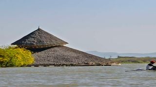
Over the years, rising water levels in Lake Baringo have claimed 139km² of riparian land and about 3,087 homes.
Property destroyed
Property was destroyed or lost, communities were displaced, and people and animals died. Many residents relocated their homes to higher ground every few months as the lake rose.
Some households have rebuilt their homes up to five times since the flooding began. Livelihoods have been destroyed as possessions were swept away and access to natural resources and even markets restricted.
Several shopping centres have been submerged, such as Loruk, and villagers must now walk long distances to find a shop or use canoes to cross the lake.
It is the same case around Lake Bogoria, Baringo County’s major tourist destination, whose water levels also increased exponentially, submerging structures and major roads leading to the reserve.
Senior Warden James Kimaru said the drastic rise in water levels in the lake had led to an exodus of flamingoes to lakes Nakuru, Elementaita, and Lokipi in Turkana County.
Some 90 per cent of the famed hot geysers, which are also major tourist attraction sites, disappeared after being swallowed up by the rising waters.
Mr Kimaru said the swelling of the lake also destroyed flamingo habitats, and the birds have no open space to feed now that the shores are full of shrubs.
“Many campsites were submerged following heavy downpours. Major roads were also swallowed up, forcing the county to spend more than Sh25 million to build alternative routes,” he said.
The flooding and the Covid-19 pandemic, he said, had reduced the number of visitors to the reserve, denting revenues by 98 per cent last year.
In Lake Nakuru, at least 677 families were affected, including 325 households in Barut East sub-location and 352 in Mwariki. The Nakuru sewerage works were also submerged. In Parkview sub-location, about 70 acres of land were also swallowed up.
At Lake Naivasha, the areas affected include the Kihoto settlement, Kamere beach and several hotels. More than 1,500 households were also displaced, with several structures and power transformers submerged, posing a serious hazard to the community.
There have also been reports of human-wildlife conflicts, with hippos now grazing closer to human settlements and attacking residents.
The report established that the Kihoto and Karagita areas were the most populated and rising waters have heightened security issues.
Furthermore, rising water levels have hurt business for tourist hotels, killing jobs.
By August 2020, 264.8 hectares of land and 170 households in Nakuru County had been affected by rising water levels and a significant proportion of the acreage affected is around Lake Naivasha, the Ministry of Agriculture said.
One solution to the rising water levels is to move people from the Mau Forest water tower, said Jackson Kinyanjui, a climate and energy expert with pan-African consulting firm EED Advisory.
“Mau Forest is the largest catchment area for most rivers feeding the lakes in the Rift Valley. This will pave the way for re-afforestation and can reduce the effects of soil erosion, which leads to siltation,” noted Mr Kinyanjui, who contributed to the report.
He also suggested drilling canals at the swollen lakes to drain away excess water, adding that the water released could be used to irrigate crops.