Kenya’s forest cover hits 8.8pc as country pushes on to attain the 10pc target
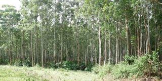
Part of the tree cover at the 104 hectares Nyangweta forest in South Mugirango in Kisii county. Kenya's forest cover has increased by almost 3 percent from 2018’s 5.99 percent to 8.83 percent.
Kenya’s forest cover now stands at 8.83 per cent from 5.99 per cent in 2018, according to the newly released National Forest Resources Assessment Report 2021.
Kenya Forest Service (KFS) chief conservator Julius Kamau said in the report that counties that recorded the highest percentage of forest cover are Nyeri, Lamu and Kilifi, which are all semi-arid. Samburu showed the most improvement as an arid county, coming in at the seventh place with 23.29 per cent cover.
The increase comes as a surprise after Environment CS Keriako Tobiko lifted the moratorium on logging in November 2020 to allow for harvesting and disposal of mature forests not exceeding 5,000ha.


Mr Kamau said that the increase is a result of the national strategy for achievement and maintenance of 10 per cent national tree cover as mandated by the Forest Conservation and Management Act.
Some of the initiatives include national tree planting campaigns, reclamation and restoration of encroached forest areas and ‘adopt a forest’ partnerships in the public and private sector.
Over 100 contributors including Eliud Kipchoge, Kenya Defence Forces and Media Council of Kenya are actively involved in the ‘Adopt a forest’ initiative.
“We have reclaimed about 30,000ha of Kirisia forest. It was a voluntary movement by the people who had resided in the forest for about 30 years. Through engagement and support from partners like the Food and Agriculture Organization of the United Nations (FAO), we were able to create awareness among the communities who realised that if they remained in the forest, it would be a tragedy. It would lead to drying of grazing lands and drying up of rivers and streams,” said Mr Kamau.
He also stated that KFS reclaimed about 9,000ha of Cheptais and Sosio Forest in Mount Elgon. With less human interference, there has been a 20.6 percent increase in tree cover in the Aberdares Forest since KFS erected a 400 kilometres fence.
Tree cover refers to woody trees of at least 2 metres height with a definite crown excluding banana trees, tall shrubs or climbers while forest cover refers to land area of more than 0.5ha with canopy cover of at least 15 per cent of trees at least 2 metres tall, which is not for agricultural or any other non-forest land use.
The six-month assessment is the first to ever analyse Kenya's tree cover, which is now at 12.13 per cent.
President Uhuru Kenyatta is pushing for the attainment of 10 per cent forest cover by this year as part of the national efforts to address climate change. President Kenyatta is currently co-chairing the Stockholm +50 environment meeting in Sweden aimed at increasing Earth action numbers across the globe.
The National Forest Resources Assessment Report further revealed that 37 counties passed the 10 per cent goal. “Arid and semi-arid lands counties such as Garissa, Makueni, Laikipia, Kajiado and Turkana have also achieved the targeted tree cover,” said Mr Kamau.
He added that Samburu and Turkana counties have great potential for increasing tree and forest cover as KFS intends to focus on more tree planting activities in arid counties in an effort to achieve 30 per cent tree cover by 2050.
Counties with the highest forest cover percentage include Nyeri (40.89), Lamu (32.13), Kilifi (26.25), Nyandarua (26.2) and Bomet (24.28) while counties with the lowest forest cover percentage include Siaya (0.23), Migori (0.31), Busia (0.56), Wajir (0.98) and Marsabit (1.11).
Counties with the highest tree cover percentage include Nyeri (45.17), Lamu (44.06), Vihiga (35.92), Kirinyaga (30.39) and Elgeyo Marakwet (29.95) while counties with the lowest tree cover percentage include Marsabit (2.06), Mandera (3.61), Wajir (4.45), Siaya (5.27) and Machakos (6.03).