Elemi Triangle politics complicates operation to end banditry in North Rift
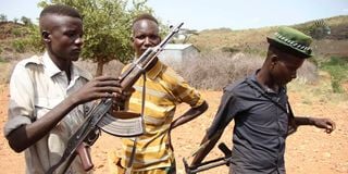
Men armed with guns at Koyasa in the Elemi triangle in Turkana County on June 10, 2013.

As the government moves to disarm the communities in the volatile North, one place will complicate the exercise: The Elemi Triangle.
The politics of this triangle informs the continued arming of the Turkana, who are constantly fighting the Dassanech and the Toposa from South Sudan's Kapoeta East County.
Last week, a vicious fight took place over the Nadapal grazing land, a contested resource between Toposa and Turkana.


There is no agreement on sharing the water and pasture, and gunfight has become the arbiter. Elemi Triangle will complicate President Ruto’s bid to disarm the communities in the north.
First, the entire Ilemi Triangle remains a contested region, and is claimed by Kenya and Sudan. If you look at the official maps of the two countries you will notice that they have yet to agree on the international border. As a result, both sides weaponise the local tribes to square it out among themselves. For many decades, Ilemi was considered too remote — and perhaps not worth any fight.
Previously, the Elemi Triangle, though always administered from Kenya, was illustrated with dotted lines. But in 1988, President Moi ordered the Kenyan cartographers to stop using dotted lines on the triangle and issue maps with a solid line instead. South Sudan was by then under the rebels. That did not go down well with authorities in Sudan.
In February 1989, the Sudan charge d'affaires in Nairobi, Ali Yousif, called a press conference and accused Kenya of incorporating an additional 6,220 square kilometres of land into Kenya after the publication of the new maps.
He was deported as Kenya's then Foreign Minister Robert Ouko said Kenya had no boundary dispute with Sudan and that Elemi was part of Kenya. But Sudan maintained that its border with Kenya followed an east-west line agreed on in 1914 by the British colonial administrations of Kenya, Uganda and Sudan.
As shown there, Elemi was also testing Kenya’s diplomatic relations with Sudan. Before the secession of South Sudan, Khartoum had threatened to give sanctuary to Kenyan dissidents over the fate of Elemi Triangle. It also accused the President Moi government of supporting John Garang’s Sudanese Peoples Liberation Army (SPLA). Moi, during the Madaraka Day speech of 1988, accused Khartoum of hosting novelist Prof Ngugi wa Thiong'o — whom he considered a dissident.
That this tiny corner of Kenya influences the gun culture among pastoralists has yet to be fully appreciated. The Elemi Triangle covers the Lotikipi Plain on the west and the Open Plain on the east. It also covers the entire Lokwana Moru Range. These are good grazing grounds.
King’s African Rifles
The problem is that cartographers disagree on which of the various international boundary lines in place constitutes the final line. It is said that in 1928, Khartoum permitted Kenya to send military units into this area to protect Turkana. Thus, Ilemi became an administrative zone under the Kings African Rifles, which set up seven police posts in the region by 1947.
Although the pre-1978 maps showed the country's northern boundary as a straight line, known as Maud Line, from the tip of Lake Turkana to the North of Lokichogio, the territorial ownership of the dotted zone was always in question.
The Maud Line was named after Philip Maud, a British engineer who delimited the northern Kenya boundary between 1901 and 1902. In 1938, Mr R.C. Wakefield, the director of Sudan Surveys, came up with what he considered the north limit of Turkana grazing.
His joint Sudan-Kenya Commission readjusted the previous “Red Line” and came up with the Wakefield Line or the Blue Line. That added another layer of confusion above the Maud Line. But the dotted Elemi Triangle line was always considered a provisional/administrative boundary. After independence, African nations adopted all the colonial boundaries without change, which is how Elemi became part of Kenya’s territory.
Finally, in 1978, the dotted lines disappeared from official Kenya maps and were replaced with a continuous line suggesting that the Ilemi Triangle was officially part of Kenya.
But the maps did not solve the politics. We see this after Southern Sudan became a republic, and it released its maps which showed Elemi Triangle as part of its Eastern Equatoria Province while Kenya puts the same within Turkana County.
Although Kenya has maintained an administrative presence in Kibish, the country's northernmost police post, and a customs office at Nadapal – this is an area to which government officials dread to be sent.
It is a complex border issue that has always been postponed or left to both Turkana and the Toposa to resolve in their own style. In last week’s skirmishes, the Toposa had allegedly infiltrated Turkana’s grazing grounds in the region, triggering a gunfight over River Napal.
Kibish Police Post
Kibish is a hostile territory. It is remote. Apart from the land that the General Service Unit camp and the Kibish Police Post occupy, the rest of the territory is usually a battlefield and is occupied by the tribe with more firepower between the Toposa of South Sudan, Nyangatom of Ethiopia and the Turkana of Kenya.
For those seeking to understand the history of illicit weapons in northern Kenya, Elemi is regarded as the birthplace of modern militarisation. The contested area is crucial for the local pastoralists due to availability of pasture and water.
In Kenya's parliament, the question over Elemi Triangle always turns emotional. In 2001, after KTN ran a map from CNN showing the Elemi as part of Sudan, then-Nyeri Town MP Wanyiri Kihoro demanded an explanation from the government. The minister said that Elemi was part of Kenya. But in what appeared to be a mischievous question, but deeply loaded, then-Kikuyu MP Paul Muite posed: “You will remember that when you and I were in school, the map of Kenya we used to draw and on which we were tested for our KAPE was different from the map of Kenya today. When did we acquire this extra territory? When did we grab, effectively, this extra territory which is now part of Kenya?”
Then Mr Adams Karauri challenged Mr Kihoro to declare his stand: “Could Mr Kihoro declare his interest because he appears to be fighting for Sudan in this House? If he is asking why the boundaries have gone that way, is he fighting for Sudan and yet he is a Member of Parliament in Kenya?”
Mr Kihoro shot back: “Mr Speaker, I am on record as having been a patriot in this country, and it is only that I am a bit confused whether I would not want to be called to the battle tomorrow to fight for something that is not Kenyan. That is why we need to know now."
Mr Muite and Mr Kihoro raised a fundamental question since Elemi is a contested territory that no leadership wants to engage in. To answer Mr Muite, the minister said: “The northwestern horn has always been ours. So, we just formalised the ownership.”
Country threatened
In 2005, while contributing to the debate on the Ministry of Public Works, Maj Gen Joseph Nkaissery challenged the house on what constitutes Elemi Triangle: “Do we know where Kibish is? Is there an airstrip? Is it maintained? There are things which we want this ministry to know so that when the country is threatened, we are able to transport troops to the affected areas and secure our people.”
As long as politics over Elemi Triangle continues on both sides, and as long as both South Sudan and Kenya allow the border communities to own guns for their survival, cleaning up small arms will be a Herculean task. Again, it is complicated by Elemi Triangle.
Postscript: In the 1990s, some allies of President Moi brought in South African mercenaries Executive Outcomes to guard Branch Energy Limited and a company owned by a State House baron prospecting for gold in the Elemi Triangle. They were also prospecting in West Pokot, and it was alleged that they created insecurity to secure territory.
[email protected] @johnkamau1