The wildlife artist turning old paper maps into art
The Peter Blackwell exhibition at the Fig and Olive

One birthday present that I especially treasure is a painting of a small herd of elephants walking across an old map of Samburu. It is by the wildlife artist, Peter Blackwell, who I first met back in 1993 when he was working as a young resident artist at the Siana Springs Tented Camp on the edge of the Maasai Mara National Reserve. He has come a long way since then as an artist.
In his website, he says he has carried out countless commissions and he has held solo exhibitions in Nairobi, London and across the USA. His first focus was on birds, and when I was with him at Siana Springs I bought a watercolour of two mousebirds scrabbling in dust. He then broadened his interests, by painting animals and landscapes. As I am writing, I am looking at another one of his paintings I have – an oil painting of a bat-eared fox.
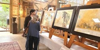
So, when we heard that Peter was holding an exhibition, mainly of his map paintings, we immediately decided to go. It was at the Fig and Olive Restaurant in Tigoni. If you read the article I wrote about it a few months ago, you will know that it is a place we rate highly. So, we treated ourselves to an excellent Sunday brunch, as well as taking in the exhibition and enjoyed meeting up again with Peter and his wife, Lisa.


There wasn’t much time for talk because Peter was kept quite busy and, judging by the number of red dots signifying sales, the exhibition was proving a success. So, I arranged to have a long WhatsApp chat with him a few days later. I wanted to know more about his journey as an artist since our meeting 31 years ago. Also, particularly, I was keen to learn more about his use of maps as ‘canvases’ for his works.
As for his journey, he said that, whatever changes there have been along the way, his focus has always been on wildlife. Before Covid-19 struck, for about 15 years he was spending a lot of time in the United States. But Covid put paid to that kind of travel. It was a difficult time, and he was looking for a new direction for his painting. The first time he used maps for background was for a small exhibition in Nanyuki.
They aroused such an interest that he was encouraged to do more. Two years ago, his main focus changed to producing map paintings. He held exhibitions at the Muthaiga Club, at Gilgil, Watamu, Vipingo and at the Matbronze Gallery in Karen. ‘The idea of using maps just took off,’ Peter said. ‘There is a lot of romance about them; they trigger memories of safaris that people have done.’
I can well understand that. The map painting I have reminds me of sitting outside a tent at Larson’s Camp and watching elephants crossing at a bend in the river. At the Fig and Olive exhibition, a painting with Tsavo East as a background sparked memories of one of the best safaris we have ever had – a mobile camp, far from any other camp or lodge, where we found a den of wild dogs.
If you would like to see what Peter’s map paintings are like, go to his website, www.peterblackwellwildlifeartist.com. There are some striking ones – a leopard resting on a map of Namanga, for example; a black rhino striding across a map of Nairobi gamepark; a dhow approaching a map of Lamu. You will see that the maps he uses are not contemporary ones; many of them are from the 1:250,000 Survey of Kenya series that used to be available at the Government Printers Office in Haile Selassie Avenue, but I gather they are no longer available.
I notice that our two sons seem never to use paper maps; they get by very well, whether walking in town or driving in the bush, by using Google Maps on their smart phones. Yes, Google Maps provide us a good service. Last month, when Lut and I were driving around southern England, even in an area where I used to live, we would have been hopelessly lost without the SatNav GPS system in our hire car, because bypasses and dual carriageways have proliferated.
We depended on SatNav for selecting the best route from where we were to where we wanted to go, establishing and adjusting the ETA – the estimated time of arrival – providing a digital map on the screen that showed our progress along the chosen route, and hearing the voice that gives route directions.
But it wasn’t enough. When I got back to Kenya, I looked for my old map-book of England, because I wanted to see how the places we had visited – Bath, Oxford, Selbourne, Winchester and Southampton – are spaced in relation to each other. It is almost impossible to see that on a car’s SatNav screen. If you try to do it by enlarging whatever is on the screen, the place names are so small, you can’t read them – even if you have better eyes than mine.
Not only that, SatNav doesn’t show you the buildings you are passing, the river you are following or the mountains you are approaching. So, though GPS navigation systems are certainly useful, they can’t give us the kind of contextual understanding that we can get with an old-fashioned paper map. I guess there are still some, like me, who prefer using maps in traditional ways alongside the digital navigation tools. Nevertheless, I reckon I will go through the old maps that are kept somewhere in a big cardboard box, and offer some of them to Peter Blackwell. He can make better use of them than I can.


