In the wild north of Tsavo East
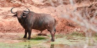
A buffalo on the bed of Tiva River.

A rough, rust-red road guides us up the shoulder of the Yatta Plateau, lifting us above an endless grey sea of scraggly bush. Up here in the more remote northern reaches of Tsavo East, the wilderness is vast and unforgiving.
Beyond the sparse network of roads and the occasional junction marker, there are few signs of human presence. Those that we do come across are decades old, and provide fascinating glimpses into Tsavo’s turbulent past.
We head further up the flank of the plateau, until our track ends abruptly at an abandoned building on the crest of a gentle ridge. Known as ‘Sheldrick’s Blind’, this basic rock-and-cement structure was designed and constructed in the 1960s by David Sheldrick – the founding warden of Tsavo National Park – as a game blind for experienced and adventurous tourists.


It was built during a period of broader infrastructural development in the wild northern section of Tsavo East, which at the time was largely isolated from the south by the high Yatta Plateau, and the Galana River flowing beneath it. Many of the current main roads across this northern area follow the original tracks carved through dense commiphora thickets in the ‘60s.
But much else changed in Tsavo over the decades that followed, and this is reflected in the sorry state of the Sheldrick’s Blind today. Across many of the musty, mud-stained walls of its interior are lines of graffiti that seem to have been written by poachers hiding out in the blind as far back as the 1980s. Poaching by highly-organised bandits decimated Tsavo’s elephant and rhino populations.
By 1988, there were just 5,300 elephants left across both of the Tsavo parks, down from a population of over 30,000 in 1967. Thankfully, the situation has improved considerably since, and the Tsavo Conservation Area is now estimated to be home to around 12,000 elephants.
We see plenty of evidence of passing herds as we descend from the plateau: the smoothed trunks of centuries-old baobabs, and giant footprints along well-trodden animal paths. The wide, dry bed of the Tiva River is pockmarked with small wells dug by elephants, which are visited by many other thirsty creatures long after the herds move on.
The Tiva is dry for much of the year, and flows only for a few weeks during the long and short rains. It begins somewhere north of Ikutha outside the park boundary, winds down alongside the Yatta Plateau, and then turns eastwards suddenly before dissipating into an expansive green delta towards the edge of the park. It is along one of the river’s wide bends that we set up our camp, on the southern bank close to Wamata Hill. Nearby is a smooth rocky outcrop that we clamber up to watch the sun sink behind the plateau, and the full moon rise above the reaching arms of doum palms.
Through the night, hyenas whoop and a leopard grunts loudly in the milky moonlight. In the morning, we hop into our 4x4s and trace the Tiva River as it cuts across the flat, barren landscape. We catch glimpses of the pinstriped coats of shy lesser kudus, as they dart out of the road and melt into the gnarly grey bush. Near the lush Roka Campsite, we drive beneath a cloud of thousands of ring-necked and mourning doves, as birds of prey circle above. And in a grove of doum palms, we disturb a small pride of slender Tsavo lions.
The Tiva generally winds around long, lazy bends, but at a place known as Bisadi it drops over a set of falls. Here, nomadic super colonies of red-billed quelea gather in their millions to drink from pools in the dry season.
To organise your own camping trip in this section of Tsavo East – where it’s wise to convoy in at least two vehicles, and where you have to be completely self-sufficient – head to www.kws.go.ke.
Email: [email protected]