How tracking elephants became my career
How tracking elephants became my career. Photo | Pool
What you need to know:
Gloria is a Geographic Information Systems (GIS) and data officer with a passion for remote sensing and works for Save the Elephants’ Elephants and Bees project
When growing up, Gloria Mugo’s family would watch movies as a bonding activity. One day, while they were watching a James Bond movie, Golden Eye, she was captivated by the huge maps which he (Bond) was referring to.
What caught her eye is how he attempted to stop Trevelyan, the main antagonist, from using a powerful satellite weapon, known as Golden Eye using a holographic map.


The map provided them with a detailed 3D representation of the base layout, including the location of guards, cameras, and other security measures.
That is when Gloria started dreaming of maps and even made a note to herself that she would do something related to maps. In high school, Geography became one of her favourite subjects.
After high school, Gloria joined Jomo Kenyatta University of Agriculture and Technology for a BSc in Geomantic Engineering and Geospatial Information Systems, a five-year course.
“When I was in my third year I did my first internship at the Martin Luther University in Halle-Wittenberg in Germany, an opportunity I got through the International Association for the Exchange of Students for Technical Experience Association (IAESTE) student exchange programme, and while in my fourth-year I worked with Oakar Services Limited based in Nairobi,” Gloria shares.
After school, and months of tarmacking, Gloria saw a call for interns with the Elephants and Bees project of Save the Elephants.
“I remembered seeing them on NTV Wild showcasing about tracking elephants with satellite collars...and I knew this was it,” she says. In May 2016 Gloria joined the Elephants and Bees project where she experienced elephants and humans competing for the same resources.
Two years later, she went on to pursue her Masters in Applied GIS and Remote Sensing at the University of Southampton, sponsored by the organisation she was working for. In 2019 she was back.

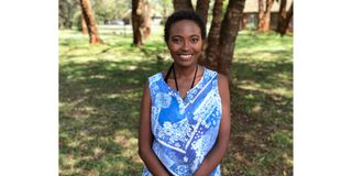
Gloria Mugo, is a Geographic Information System (GIS), and data-based officer, at the save the elephants and bees project. Photo | Pool
Today, Gloria is a Geographic Information Systems (GIS) and data officer with a passion for remote sensing and works for Save the Elephants’ Elephants and Bees project.
“My interest in elephants was piqued when I read about the use of satellite collars to track or monitor the movement of the animals,” Gloria says.
As a geospatial technology specialist, she studies the earth using tools and technology such as satellites or cameras mounted on aircraft, to collect and analyse data about the earth’s surface and atmosphere.
“The information from this data can be used for a variety of purposes, such as mapping built features, for instance, roads, and buildings, natural resources such as rivers and lakes, monitoring environmental changes such as after forest fires or floods, and studying urban development,” she says.
With this information, Gloria is able to analyse the natural vegetation in the environment with respect to the elephant species.
For instance, the elephant bull will choose to walk a separate path from an elephant family consisting of females and young elephants, purely driven by the need to get to specific wild vegetation that is eaten by the bull.
“Interestingly enough, we also found that in situations when the bulls would walk in a group with the females and young, they would take paths that would lead them to areas where there would be plant species that are preferences for either or of the genders, thereby serving the needs of all members of the group,” she shares.
From the data collected, Gloria is able to inform residents of Tsavo and Voi about which paths elephants use and why. Additionally, she is able to advise on which plants should not be planted on the elephants’ paths and the need for bees to protect people’s farms.
Elephants, she says, are attracted to some crops with farmed crops like—maize, green-grams, cassava, and watermelons—being on their list of favourable diet options.
However, all is not lost, through her research, Gloria notes, “We have educated farmers living in such conflict areas such as the Sagalla village in Voi, where our research center is located, to grow the sunflower crop instead of the usual maize and pigeon peas which will attract the elephants to their farms,” she says.
Sunflowers, for instance, don’t need too much water to grow, this is a plus as the bees around their farms can benefit from having fodder, thereby ensuring the beehive fence used as protection remains live with happy healthy bees. Farmers also benefit from the opportunity to sell sunflower seeds as an alternative source of income.
Though the research is beneficial to the community, Gloria notes that just like every other career, there are challenges. Her biggest one is managing the expectations of community members.
“When faced with calamities like drought a lot of farmers retreat to their usual practices, despite being in the know-how that they would be facing the same issues of crop raids,” Gloria says.
The other challenge is on how best to relay their work to leaders. “This is not just the findings, but the inner workings that go into remote sensing research that enable us to come up with valuable findings,” she adds.
Gloria feels fulfilled when her work is adopted by the community and is included in local actions and at policy level.
“My work being recognised globally is also a great motivator. This will be a huge reward coming off the back of many work hours and being passed up due to motherhood,” Gloria shares.
When she is not studying elephants and maps, Gloria spends her time navigating the ebbs and flows of motherhood and the family way.
“It is a whole other dimension that commands commitment. I am a wife to the good man Stephen Njogu and together we have two beautiful children who constantly keep us on our toes,” she notes.
Gloria has also embraced equity.
“Be it as it may, the times we now live in do not allow for complacency so show the world that being a mom is not a crown of ineptitude. To stump out such micro-inequities, I've used my skills and deliverables which don't have on them a mark of 'mom' or 'female'… they just speak the language of excellence, high standards, quality, accountability, and consistency,” she explains.
Gloria notes that geospatial technology has been, is, and will remain to be a vital part of any civilisation. Critical as it is, she adds that developing technical skills even when in employment is a must-do.
“Since this technology is used in many fields and industries such as in conservation, it is important to gain domain knowledge and experience in the particular area to help you stand out and advance in the career,” she advises.
And finally, Gloria says, “do not forget to enjoy the experience. It is a fun place to be and sometimes the workload can take the joy out of it, but it is important to never forget to be happy in that space.”