Suswa havoc: Human activity has caused damage that is costly to fix
The gulley in Suswa. The increasing degradation of ecosystems and the growing impact of climate change urgently call for a change in the way we manage our natural resources, particularly soils and forests. PHOTO | FILE
What you need to know:
- The increasing degradation of ecosystems and the growing impact of climate change urgently call for a change in the way we manage our natural resources, particularly soils and forests.
- How many of us are aware that it can take up to 1,000 years to form one centimetre of soil?
- Despite the important role soils play in our economy, our soils are being destroyed and in most places.
- Land has lost its productivity due to overexploitation and soil erosion.
Mother Nature is on a very serious revenge mission in this country, as recent events indicate. Before discussing the events that took place in Suswa, let’s first revisit a few fundamental facts.
The increasing degradation of ecosystems and the growing impact of climate change urgently call for a change in the way we manage our natural resources, particularly soils and forests.
NATURAL RESOURCES


But why pay special attention to these two natural resources?
First, soil is a finite resource, meaning that once it is lost or degraded, it is not recoverable within a human lifespan.
As a core component of land resources, agricultural development and ecological sustainability, soil is the basis for human and animal food, fuel and fibre production, and for many critical ecosystem services.
It is, therefore, a highly valuable natural resource, yet it is often seriously overlooked and overexploited. Its preservation is essential for food security and a sustainable future.

Mining PS John Omenge and a team of geologists during a tour of the Maai Mahiu fissure and Suswa flood-prone area on April 22 2018. PHOTO | GEORGE SAYAGIE
A few basic questions: How many of us are aware that it can take up to 1,000 years to form one centimetre of soil? And did you know that nowhere in nature are species so densely packed as they are in soil communities, and that many of the world’s terrestrial insect species live in the soil during at least some stage of their life cycle?
Do you appreciate that soils help combat and adapt to climate change by playing a key role in the carbon cycle, and that they can sequester around 20 petagrams of carbon in 25 years, more than 10 per cent of the anthropogenic emissions (see terminology box)?
Are we aware that the top metre of the world’s soils store approximately 2,200 gigatonnes (a billion tonnes) of carbon, which is more than three times the amount of carbon held in the atmosphere?
Yet we talk about global warming without appreciating the role this important natural resource plays in reducing the rate of enrichment of atmospheric concentration of carbon dioxide.
ROLE OF SOILS
What is more disturbing is that, despite the important role soils play in our economy, our soils are being destroyed and in most places, land has lost its productivity due to overexploitation and soil erosion.
Finally, how many of us pay attention when we see, during the rainy seasons, rivers, lakes and other water bodies laden with sediments that contain the most fertile soils and nutrients that are essential for plant growth? Has the Kenya National Highway Authority (KeNHA) ever bothered to know the source of the huge amounts of sediment deposited along the Maai Mahiu road, leave alone the infrastructural damage that comes with such overland flow?
Now let’s look at some basic facts about forests. Forests provide livelihoods for more than a billion people and are vital for carbon sinks, conservation of biodiversity, energy supply, and soil and water protection.

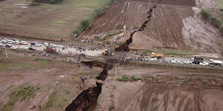
A visible fault line in Karima area, Maai Mahiu, Naivasha in March 2018. The owner of the house vacated his home. PHOTO | MACHARIA MWANGI
One of the most vulnerable natural resources highly threatened by human beings is the forest. For instance, using multi-temporal remote sensing images and field-based studies in the Mount Suswa catchment, it was found that bare land increased from about 1.21 square kilometres in 1985, to 2.46 square kilometres in 2011, a 103 per cent rise.
On the other hand, the area under agriculture increased by 23 times, from one square kilometre in 1985 to 23 square kilometres in 2011. All these took place at the expense of grassland and shrubland, clearly indicating that the hand of man was at work clearing the natural vegetation.
The recommended forest cover by the United Nations is 10 per cent, while the average for Kenya in 2016 was about 7.14 per cent. The figure shows that most of the counties’ forest cover is less than 10 per cent and only 18 of the 47 counties have attained 10 per cent cover, according to 2016 data, and the fear is that after the ongoing forest audit is done, there is a huge possibility that this cover has declined, given the massive destruction of forests that has been taking place.
Having briefly highlighted the importance of soil and forests as natural providers of ecosystem services, let us look at a few points regarding what has been happening in Suswa. This time from a pedologist’s point of view.

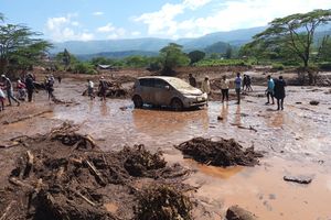
A section of the Maai Mahiu-Narok highway that was damaged by raging flood water at Karima area in March 2018. PHOTO | MACHARIA MWANGI
ENVIRONMENTAL CONCERN
In the recent past, Narok has been identified as one of the hotspots of environmental concern in the country due to the massive production of charcoal, which has a ready market, both locally and in the adjacent urban areas. Coupled with overgrazing and deforestation, the conversion of natural grasslands and forests into cropland has led to severe land degradation in an already highly fragile ecosystem.
Dense gully (considered the worst stage of water erosion) networks dissect the area’s landscape and these gullies widen every time there is a downpour. Network expansion and channel widening go together, with mass wasting acting on the gully channel walls and potentially threatening humans and livestock.
The channels in Suswa already make it difficult to practise agriculture, while such severe landscape dissection leads to the destruction of the infrastructure, as is already happening on the Maai Mahiu-Narok Road.
The photo that appeared on the cover page of the Daily Nation on March 20, 2018 and the explanation given for it: One, the photo shows a landscape void of any vegetation cover, obviously making the area very prone to erosion. The gully—I won’t call it a fissure—is a typical feature every time this area experiences downpours.
This is not the first time the Maai Mahiu-Narok Road is being rendered impassable by rain. The fact is that overland flow from the Suswa Hills is the main culprit, not a geological tremor. The soils in Suswa are the so-called andosols (young volcanic soils) that are extremely vulnerable to gully erosion and landslides if they are mismanaged. They are characterised by a high silt:clay ratio, and low organic matter content, properties that make them even more prone to erosion.

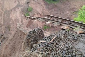
Suswa Gulley. PHOTO | COURTESY
DEGRADATION
An assessment of the carbon management index (CMI – an indicator for soil degradation or improvement in response to land use and land cover changes) showed that the agricultural lands have higher CMI than grasslands (53 per cent against 41 per cent relative to shrubland) suggesting that grasslands in Suswa face serious degradation through overgrazing, a recipe for land degradation and gully formation.
So what makes these soils so fragile? Their top, moderately deep layer, is underlain by very loose material (this is the black sand that is usually harvested for building). Once water seeps into this loose material, lateral seepage occurs, accompanied by underground piping, scouring and tunnelling, and finally, the top layer of the soil collapses, exposing huge gullies. The end result is the formation of huge gullies that continue deepening and widening due to this loose material.
Second, could such a tremor induced-fissure (measuring 15 deep and 20 wide as reported) not have caused unprecedented destruction?
If it was a fissure caused by an earthquake, remember that the December 24, 2014, tsunami killed more than 280,000 people in 14 countries, yet it only displaced the sea floor by nine metres horizontally.
The reported dimensions of this fissure would make it look like a joke when, just three or so kilometres upslope from Nduka Moja Shopping Centre towards Mt Suswa there are gullies almost bordering on canyons in Olesharo, a sub-catchment of the Suswa catchment. Here livestock and people cannot cross easily from one side of the gully to the other.
STUDY ON GULLY FORMATION AND ELOPMENT
This author, with a team of experts from the Kenya Agricultural and Livestock Research Organisation, Jomo Kenyatta University of Agriculture and Technology, the Kenya Forestry Research Institute, the Ministry of Agriculture Livestock and Fisheries, postgraduate students from the University of Nairobi, and the local community, studied gully formation and development, their causes and rehabilitation.
The study was supported by the Mainstreaming Sustainable Land Management in Agro-pastoral Production Systems of Kenya Project financed by the Global Environmental Facility (GEF), the United Nations Development Programme-Kenya (UNDP-K) and the government through the State Department of Livestock and the Ministry of Agriculture, Livestock and Fisheries.
The activities involved massive rehabilitation work. LandSat images showed that these gullies were not there in 1988, an observation also confirmed by the local community using participatory geographical information system (PGIS).
From the PGIS studies, the main drivers of gully erosion were identified as an increase in bare land and agricultural land, and a reduction in grassland, meaning the hand of man is at work in Suswa, so and we should not blame the tremor!
According to the study, Olesharo has lost 313,750 tonnes of sediment due to gully erosion within a span of 20 years. It is part of this large amount of eroded soil that is deposited along the Narok-Maai Mahiu Road, making it temporarily impassable during heavy rains.
The rehabilitation of the Olesharo sub-catchment gullies involved establishing numerous soil and water conservation structures such as water retention ditches, terraces, cut-off drains, semi-circular bands, water pans, check dams and planting of trees in degraded areas.
The project also supported the establishment and training of more than 120 farmer field schools members on sustainable land management practices, including sustainable charcoal production; pasture establishment and improved livestock breeds, all to enhance the regeneration of vegetation.
One water pan with a capacity of 20,000 cubic metres, retention ditches totalling 16,300 metres (900 metres of semi-circular bands and check dams) and 910 metres of brushwood strips and cut-off drains were constructed. Four years after the rehabilitation work, the Olesharo sub-catchment gullies have been healed and the land is once again productive. Worth noting is that the Olesharo has survived the current rains! It is the same hand of man that has done this, but at a very high price!
Finally, there is a need to urgently control and rehabilitate the gullies the in Suswa Hills to avoid degrading the land in the area any further. Controlling and rehabilitating gullies is the most costly endeavour of soil erosion control.
It is time an organisation like KeNHa got involved in rehabilitating the surrounding catchment, even if only by providing tree seedlings. Otherwise this will be a recurrent problem.
The best strategy is to prevent the formation and development of gullies through proper land management and soil conservation. It is also recommended that an integrated approach that incorporates sustainable land management and climate change be used to offer more benefits in combating land degradation and increasing resilience and adaptability to climate change.
This will require a review of the policies related to land management, together with supporting integration and mainstreaming of sustainable land management into the national planning processes and implementing land management approaches, techniques and technologies. Pending relevant policies on sustainable land management require immediate attention.
The National Agricultural Soil Management Policy Draft (NASM Policy) supposed to be spearheaded by the Ministry of Agriculture is yet to see the light of day.
Yet this comprehensive document outlines, in clear terms, the measures that should be taken to restore, conserve and maintain the country’s soils.