Slice of Kaya forest under threat of destruction by the state
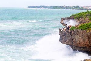
The sacret Kaya forest of the Mijikenda.
A section of the Kaya forest in Kwale County is under threat of destruction as the government plans to use it for the construction of an electricity transmission line.
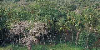
Kaya Gandini, one of the sacred forests of the Mijikenda community, is located at Kasemeni in Kinango.
Kaya forests are listed as national monuments and as United Nations Educational, Scientific and Cultural Organization (UNESCO) World Heritage Sites.


In a gazette notice issued on Friday, February 23, the state listed over 300 parcels of land belonging to individuals and institutions that are to be acquired to construct the Mariakani – Dongo Kundu 220 KV electricity transmission line.
Among the land being eyed by the government is 0.1970 hectares, which is equivalent to about 0.5 acres of the Kaya forest. Documents seen by Nation.Africa estimate the total size of the forest to be 150 hectares (370 acres).
The power project is meant to supply electricity to the anticipated Sh39 billion Dongo Kundu Special Economic Zone in Mombasa, which is being developed by the national government with support from the Japan International Cooperation Agency (JICA).
“The National Land Commission (NLC) on behalf of Kenya Electricity Transmission Company Limited (KETRACO) gives notice that the National Government intends to acquire a wayleave corridor on parcels of land listed below for the construction of 220 KV Mariakani – Dongo Kundu Transmission Line in Kwale/Kilifi counties,” a section of the gazette notice read.
The gazette notice signed by NLC Chairman Gershom Otachi states that the project will consist of construction of towers and conductors overflying the listed parcels of land.
However, it adds that details of compensation will be communicated to the affected individual land owners.
“Pursuant to section 146 of the Land Act, 2012, any representations/objections regarding the wayleave should be made to the National Land Commission,” it states.
Under UNESCO, Kaya Gandini is listed as one of the secondary Kayas associated with the Duruma tribe of the Mijikenda, besides Kaya Mtswakara.
The forest is famed for its biodiversity in bird species and indigenous trees.
It consists of a large central clearing that is kept cleared for animals to parade seven times before ritual slaughter and a place known as ‘chizani’, the most sacred site of the Kaya. The site is kept wet at all times, and is only accessible to members of the Supreme Council of Elders, according to filings at UNESCO.
Other forests that are used by the Mijikenda elders to perform traditional ritual prayers are Kaya Giriama (Fungo), Jibana, Kambe, Ribe, Kinondo, Kauma, Mudzimuvya, Bomu and Fimboni.
However, the forests have been facing threats from human activities including logging and land grabbing in the recent past.
A technical assistance report by JICA dated January 2022 for the development of the Dongo Kundu SEZ stated that “conservation of Kayas should be considered for environmental countermeasures”.
Other institutions and companies whose pieces of land are listed include the County Government of Kwale, Urithi Housing Co-operative Society Limited, Koichi Realtors Limited and Guriro Limited among others.