Explainer: Why Kisumu often floods
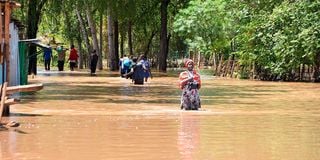
Residents of Kamidumbi village in Ahero town wade through floodwaters to reach their homes.

Whenever it rains in Kisumu, it almost always floods. More than 40,000 people in the county have already been displaced, either in evacuation camps in various schools or by staying with family and friends on higher ground.
The floods also expose residents to poverty due to loss of property, water-borne diseases and food insecurity caused by damaged crops.
Since the beginning of the rainy season, three people have been hospitalised due to bilharzia and typhoid infections. Areas usually affected by flooding include Kolwa Central, Kolwa East and Kajulu. Nyalenda B, Kisumu Central, Ombeyi Ward in Muhoroni Sub County, South West Central wards in Kisumu West and Kadibo are also prone to flooding.


So why does this lakeside region persistently flood? Several factors contribute to this:
Topography
Kisumu's topography combines flat land (the basin) and hilly areas such as Riat, Nyahera, Maseno and Nyabondo. Unfortunately, whenever there is run-off from the Nandi Hills, all the water settles on the lower flat land - the Kano Plains. This topography makes the area prone to flooding.
In addition, Kisumu's wetlands are increasingly under threat as private developers encroach on the land to build modern high-rise buildings.
Encroachment on Wetlands
There are several wetlands in Kisumu, including Dunga, Ombeyi, Nyando, Kusa, Namthoi, Koguta, Chiga and Kisat. Wetlands are essential for flood management and prevention. However, when these areas are encroached upon, people face the consequences of nature's wrath. Wetlands include swamps, marshes, peatlands and bodies of water less than six metres deep.
According to Christopher Aura, head of freshwater systems research at the Kenya Marine Fisheries and Research Institute (KMFRI), encroachment on wetlands threatens their biodiversity and increases water pollution.

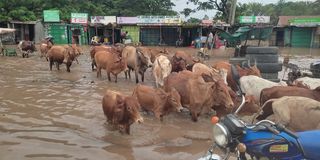
Flooded Ahero Town after River Nyando burst its banks on May 4, 2024.
Many wetlands provide habitats for wildlife and breeding grounds for fish. They also play a crucial role in filtering river water, which often carries a significant amount of waste into Lake Victoria. But when people encroach on these wetlands, they reduce the areas that act as protective buffers or filters for the lake.
Soil degradation
The growing demand for sand for construction has led to a steady increase in environmentally unfriendly activities on the rivers and shores of Lake Victoria. Sand mining exposes river banks and beds to erosion and destroys aquatic life. In Kisumu, sand mining is rampant in the Kibos and Nyamasaria rivers. The activity has also spread to several beaches around the lake.
Poor agricultural land use upstream has also led to severe siltation of Lake Victoria. The silt has been found to contribute to the growth of the obnoxious water hyacinth weed and reduce the depth of the lake.
Climate change
Flooded Ahero Town after River Nyando burst its banks on May 4, 2024.
Kenya has historically had two main rainy seasons: the long and the short. The long rains usually fall between March and May, while the short rains fall between October and December.
However, due to global warming and drastic climatic changes, rainfall patterns have suddenly become unpredictable. For example, the short rainy season sometimes extends into January. Unpredictable weather also means that sometimes the rains are heavy for a short period of time, causing flooding. Prolonged rains cause flooding, mudslides and landslides.
Lack of forest cover
The water level of Lake Victoria has risen by 14 metres so far. According to Leornard Ofula, Kisumu County Director of the National Environmental Management Authority (NEMA), one of the main reasons for the lake's overflow is the excessive accumulation of silt in the lake basin.
Mr Ofula argues that much of the soil eroded from upstream in the catchment areas is washed into the rivers and swept into the lake.
"You realise that a lot of agricultural activities are going on around these catchment areas, but because we do not have enough forest cover, all this silt is being carried into the lake by the rivers," he said.
Mr Ofula proposes that the Council of Governors should take the lead in promoting soil conservation through tree planting.
"The issue of soil and water conservation needs to be revived to ensure that the silt is retained upstream so that it is not washed into the lake," he said.
Lake Victoria gets its water from several major rivers, including the Nyando, Yala, Nzoia, Miriu and Kuja. Its catchment areas are Nandi, Vihiga, Siaya, Kakamega, Homa Bay, Migori and Kisii counties.
Domnick Arodi, Siaya County Director of Meteorological Services, explains that flooding occurs when run-off from a catchment area accumulates.
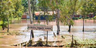
Submerged Kobura Primary School in Ahero Town.
For example, the catchment area of the Nyando River includes Nandi, Kericho, Muhoroni and Nyando. He argues that cultural beliefs about land ownership among communities have always prevented residents from moving off their ancestral land.
Mr Arodi proposes that county governments start dredging the rivers, which often burst their banks.
Man-made activities such as diverting the course of a river for agricultural purposes could also act as a mitigation measure, he says.