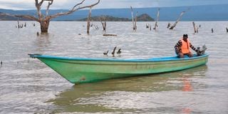
Wilson Lemukut, a resident of Kokwa Island in Lake Baringo, Baringo County steers his boat on the lake on April 24, 2024.

The European Union (EU) has committed to pumping Sh1.9 billion (14 million Euros) to support the rehabilitation of the degraded watershed orchestrated by human activities upstream, causing siltation in Lake Baringo, thus leading to flooding.
This comes amid concern that the effects of climate change have taken a toll on farmers in the region, including flooding and drought.
To mitigate its effects, Baringo County Governor, Benjamin Cheboi, has revealed that the devolved unit is partnering with the EU on a project that will support the Lake Baringo watershed.
“The challenges of erosion of land upstream are real. It is because of land degradation upstream due to human activities such as deforestation and agricultural activities that have led to perennial flooding in Lake Baringo during the rainy season and drought during the dry season,” said Governor Cheboi.
“The EU has approved a grant of 14 million Euros to rehabilitate the degraded land, and the project is targeted to be implemented next year. Through this project, we shall be able to turn around the lives of the affected people living adjacent to the lake. We also urge the locals to continue planting more trees, especially in riparian areas,” he added.
EU program manager, Thomas Yatich, said they look forward to working with the devolved unit in implementing the project on climate resilience watershed that has led to the rising in Lakes Baringo and Bogoria over the years.
“The national government came to the European Union and sought support for the rehabilitation of watersheds that drain its waters to Lake Baringo and manage sedimentation. We hope to enter into a partnership to implement the project next year and we are in the process of discussing the modality of implementation and we invite other development partners to work with us to enhance the productivity of the ecosystem,” said Mr Yatich.
In 2021 for instance, the flooding in Lakes Baringo and Bogoria led to the displacement of more than 10,000 people from their homes, forcing them to seek refuge in temporary camps in safer villages after their houses were completely swallowed by the lake waters.
Among the worst-hit villages are Loruk, Noosukro, Kokwa Island, Kampi Samaki, Sokotei, Lorok, Kiserian, Ruggus, Loitip, Mukutani Ndogo, Ng’ambo, Sintaan, Salabani, Ilng’arua, Loboi and Longeiwan.
The flooding also led to the submersion of six health facilities; Loruk, Kambi Samaki, Loboi, Salabani, Ng’ambo, and Ol Kokwe Island, which has hindered access to medical services for people living in the area.
Soi Safari Lodge, Roberts Camp, Lake Breeze, and block hotel at the shores of Lake Baringo also suffered heavy losses after the lake burst its banks, which saw hundreds of rooms and cottages engulfed in flood waters.
The same scenario was also witnessed at Lake Bogoria, Baringo County’s major tourist destination, which had increased exponentially, submerging structures including the main gate and major roads leading to the reserve.
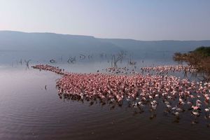
According to the National Reserve senior warden, James Kimaru, the drastic rise in water levels in the lake had led to an exodus of the flamingoes to Lakes Nakuru, Elementaita, and Lokipi in Turkana County.
The famous hot geysers, which are also major tourist attraction sites, had also disappeared by 90 percent after they were swallowed by the rising water levels.
Research carried out by the Kenyan government since October 2020 in collaboration with the United Nations Development Programme (UNDP) to explain the tremendous rise of water levels in Rift Valley lakes, attributed it to climate change, siltation caused by human activities, and geologic and tectonic activities.
Climate change was recorded as the main reason for the rising water levels, indicating that changes in land use practices have led to increased runoff, causing larger volumes of water to flow directly and rapidly from the land surface into the lakes.
The increased inflow of fresh water into some of these lakes has created instability in the already fragile ecology of the lakes, negatively affecting the resilience and distribution of certain water species.
Their cause, the report said, is largely attributed to anthropogenic threats to the freshwater ecosystems, mainly water quantity effects like deforestation and excessive water abstraction from the lakes, rivers, wetland systems, and groundwater.
Kenya experiences bimodal rainfall seasons with long rains received in the March to May season and short rains received in the October to December season. The January to February period is usually hot and dry, while the June to August season is usually cool and dry, even though it is becoming one of the rainy seasons in the Western part of Kenya due to climate change.
In 2019, Kenya generally received higher rainfall than the long-term mean with the October to December season experiencing one of the highest ever recorded rainfall, only comparable to that in 1961 and 1997.
Land degradation was also cited as among the causes of the flooding, owing to the forest cover in the water towers including Mt. Kenya, the Aberdare range, the Mau Complex, Mt. Elgon, and the Cherangany Hills that have significantly reduced over the years.
“This has contributed to the disruption of the hydrological cycle and to soil erosion which is one of the major causes of the happening in all the lakes. Some of the factors that have contributed to the changes in land use observed across the water basins include increased population, urbanisation, intensified agricultural activities, and poor management of forests, which has increased precipitation in the rainy seasons, and ensured the permanent flow of rivers during the dry seasons,” read the report.
Geological and tectonic movements are also another reason for the exponential rise in the water levels in lakes within the Kenya Rift Valley since 2010.
The research indicates that the lakes in the Rift Valley have undergone significant geological and historical changes with recent history showing a significant increase in lake water levels in 1901, 1963, and presently since 2013.
The rift system hosts several lake basins of varying sizes, whose depositional environments are largely influenced by tectonic, volcanism, and climate-driven processes.
The report, which was based on their research from 2010 to 2020, established that Lake Turkana increased by 10 percent from 7,485km square to 8,265 km square.
Lake Baringo also increased exponentially from 128 km square to 268 km, a rise of more than 108 per cent.
Lake Bogoria on the other hand also rose by more than 25 per cent, from 34 km to 43kms square, while Nakuru also rose from 40kms to 68kms, an increase of 70 per cent respectively.
Over the years, the rising water levels in Lake Baringo have claimed 139.98 km² of riparian land and approximately 3,087 households of communities living around the lake have also been immensely affected.
Lake Baringo was one of the worst affected lakes in the Rift Valley flooding with an estimated area of 108.57 km2. The flooding displaced several settlements bordering the lake particularly the Southern and the Western parts.
The flooding has caused major disturbances including the destruction and loss of property, displacement of communities, and loss of animal and human lives. Many have been relocating their homes to higher grounds every few months as the lake rises.
Some households have rebuilt their homes up to 5 times since this began. Further, the rising water levels have disrupted communities’ livelihoods by destroying and sweeping away the little available possessions and restricting access to natural resources and even markets.
Several shopping centers have been submerged, for example, Loruk, and villagers therefore have to walk long distances of about 5km to find a shop, or they have to row canoes across the lake.