Shakahola forest: Satellite imagery analysis reveals key details of the ‘death triangle’

On the morning of April 13, police were tipped off on the possibility of a crime inside the Shakahola forest.
Subsequently, 15 emaciated people were discovered inside the forest. Four of them were so weak that they died before reaching the hospital.
The following day, police began combing through the forest more systematically and on April 21 it emerged that there was much more to the forest as mass graves were discovered.


As the damning revelations sent shockwaves across the country, President William Ruto said the government would form a judicial commission of inquiry to establish why Pastor Paul Mackenzie’s questionable activities went on undetected for such a long time.
Interior Cabinet Secretary Kithure Kindiki declared Shakahola a scene of crime after a visit to the site on April 25.
Things took a different turn altogether when the police barred journalists from accessing the Shakahola forest on April 26. The police termed the 800-acre land—where more than 200 buried bodies have so far been exhumed—is a disturbed area and an operation zone.
However, these events presented unending questions over how long these acts went on inside the forest.
The Nation has examined and compared satellite images and witness statements as it seeks to expose the reality of the Shakahola tragedy and how the forest became a killing an burial fields.
It is important to note that while this satellite imagery is significant, it does not replace evidence obtained from the crime scene. But it goes a long way to help us understand what had been happening inside Mackenzie’s tightly controlled villages.
Identifying the location
Having been locked out of Shakahola forest, satellite imagery was our sole method of visual evidence of activities and settlement.
For thorough verification, and to help with investigating where the killings and burials occurred, geolocation was a priority task.
Our investigative unit, which reported from the scene, shared the live coordinates for this location. Using the codes, we positively pinpointed the location where exhumations had occurred inside the forest.
With the hypothesis that this was the location of Shakahola village in mind, we mapped out a triangle a little more than three square miles in size—approximately 1,920 acres—to identify the changes over time.
Image courtesy of Google Earth
Shakahola forest lies to the southeast Kenya in Kilifi County, 69.9 km from Malindi town. It is an isolated forest next to C103 highway, which connects Taita-Taveta to Malindi.
Its location may indicate why activities went on undetected for a long period. The sparsely populated area of Shakahola has little infrastructural development as seen on images by Google Earth Pro.
Order of events
Through the Sentinel Hub chronological satellite timeline, the Nation was able to establish the activities inside the forest as from 2020.
Sentinel Hub is more frequently updated than Google Earth satellite imagery, so our team was able to effectively narrow down dates.
For a start, we needed to detect the changes in vegetation cover over the years. Using the colour infrared filter to identify vegetation, we discovered a significant difference in vegetation cover between October 22, 2020 and March 11, 2023.
Sentinel hub
Sentinel hub
In the images we noted that in October 2020, the area surrounding the village was intact with dense vegetation, but in March 2023 there were brown spaces within the forest.
By being certain that there were activities that occurred within our area of interest, we now began tracking down the changes.
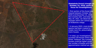
Upon scrutiny of the satellite imagery within our triangle, we discovered that the first activity inside Shakahola forest occurred between October 22, 2020 and December 21, 2020 when a section of the forest was cleared.
Satellite image of Shakahola forest on 20th October 2020
Two spaces that appear to be open fields and a water pond were the first demarcations inside Shakahola village.
A section of the cleared forest
Five months later, precisely on May 20, 2021, we observed changes were going on inside the forest and the spaces were now becoming widespread, especially in the central part of Shakahola village. In a closer view, more of the brown signature markings are visible.
A section of Shakahola forest on May 20th 2021
By October 2021, a year later, more changes were going on inside the forest and the brown spaces were now conspicuous.
Satellite image of Shakahola forest on 2nd October 2021
In January 2022, more brown spaces appeared, to create room for, presumably, more houses.
Satellite image of Shakahola forest on January 30th, 2022
More demarcations marked the central part of the village by July 19, 2022 and the expansion started moving southwards. At this time, it was apparent that more settlements had now sprouted inside Shakahola village.
Satellite image of Shakahola forest on July 19th, 2022
By March 2023, we were certain that there were human activities inside the Shakahola forest. The brown patches had significantly spread as empty patches were left behind.
Satellite image of Shakahola forest on March 11th, 2023
To substantiate the changes, a comparison between two dates can be made to see what has changed in this village.
A chronological comparison of the triangle shows significant vegetation had been cleared and there were more brown patches on the earth within the triangle.
Identifying homes
After narrowing down the chronological changes using Sentinel Hub, the next step was highlighting our findings by investigating human settlements.
Media reports indicate that Mackenzie lived with hundreds of followers in makeshift homes in the remote forest, and had demarcations of areas with biblical names like Jerusalem and Judea.
A closer look at Apple maps in May 2023 revealed sections of the Shakahola village had actually been demarcated, providing further proof of the latest human activities inside the forest.
Apple Maps Satellite image of Shakahola forest in May 2023
Using satellite imagery from Apple maps, we conducted a headcount of the visible houses inside Shakahola village.
We were able to identify some of the houses in the satellite image based on shape and colour of the rooftop and also the vicinity of the rooftops, considering a Kenyan traditional compound set-up.


These two structures(Marked in red) appear to be skeletons of a once inhabited houses.
At the tail end of this open field, we can see what appears to be a water pond and a few metres away the satellite images captured animals grazing.
In total, we counted 120 houses within the forest. However, the number of houses could be higher given the number of bodies and the approximation method we used.
Since the exhumations began, more than 200 bodies have been recovered and the exhumations have been done in two phases. As they continue, the fear of far more bodies being found becomes real, considering how vast the area is.