Excursion in Kerio Valley
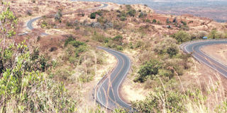
The road from Marigat to Kabarnet and beyond is amazing. Before the turn to Kabarnet, we catch a glimpse of Lake Baringo dazzling in the Great Rift Valley. PHOTO| RUPI MANGAT
What you need to know:
Kabarnet is a little cooler with the purple jacaranda and luscious orange of the erythrina in bloom.
The town is full of people, broken roads and pavements spilling mitumba – yet the setting is picturesque.
A town built in the hills – something town planners could turn into a beautiful hillside resort town.
The road from Marigat to Kabarnet and beyond is amazing. Before the turn to Kabarnet, we catch a glimpse of Lake Baringo dazzling in the Great Rift Valley.
The road is lined with bone-dry Acacia reficiens under a blazing sun. The only greenery is the Prosopis juliflora (mathenge), the invasive plant that sucks the underground water table and spreads like a ‘green desert’.
A few kilometres inroad, a power plant is nearly complete. It will use the prosopis to generate power – which means that there will always have to be enough of the weed to harvest for the factory.


The road begins to go up the Tugen escarpment with pockets of farms and homesteads. On the very highest slopes, farmers terrace the slopes. Standing at the viewpoint, Baringo shimmers enticingly in the horizon.
Kabarnet is a little cooler with the purple jacaranda and luscious orange of the erythrina in bloom.
The town is full of people, broken roads and pavements spilling mitumba – yet the setting is picturesque. A town built in the hills – something town planners could turn into a beautiful hillside resort town.
The descent into the valley of Kerio is rapid with hairpin bends, twists and turns. At the floor of the valley, at the turning to Kamnarok, the reserve is 38 kilometres away.
Despite it being late afternoon, we take the dusty road to the little lake that came into being during the floods of 1961. At the time, Kerio River burst its banks and spilled its waters far and wide. People living in the floodplain were airlifted by helicopter to higher ground.
There’s a trading centre every few kilometres. It’s mango season and we bite into the juiciest mangoes from the roadside kiosk at five shillings a piece.
An hour later we’re at Lake Kamnarok, an ox-bow lake surrounded by the hills and brimming with water because the outlet to the river has been blocked. A few years ago, it was dry. The crocodiles had either died or left for the village pond where they had no energy to snap at anyone.
Surreal
It was surreal watching women collecting water with the crocodiles just lying there.
In the early evening, the colours of the lake are mellow and the birds are out foraging: jacanas on the lilies, African fish eagle, ducks, African spoonbills and more, but no crocodiles. The winds churns the water. Meanwhile schoolchildren are out with their yellow debes to collect water from the lake while the boys bring the goats home.
We stroll a kilometre away from the lake, and we’re at Kerio River, a major river, flowing northward through the Kerio Valley between Tugen Hills and Elgeyo Escarpment, to enter Lake Turkana.
There’s no water in it save for a big puddle where a seasonal stream would flow into it. Over the years the river has shifted course and moved into Kamnarok Game reserve. Across the river is Rimoi Game Reserve.
A woman fills her debe with water but first she has to scoop out the sand with her hands. The water is crystal clear. Other scooped holes litter the sandy riverbed. Walking in the riverbed, there are piles of elephant dung and in the dung, thriving saplings of water-melon.
Across the river, we walk through the scrub into Rimoi National Reserve where a few years ago we watched a herd of elephants. Back in the riverbed, a trio of Tugen men carry a hollowed log to turn it into a water trough. Meanwhile, the family on the river’s bank switches on the pump to water their shamba.
Back into Kamnarok, the goats munch on seeds and spit them out. The park ranger picks one, skins it and chews on it. I do the same – it’s a bitter-sweet taste – much stronger than the doum palm fruit. It’s fruit from the balanites tree also called the desert date -- a healthy, local delicacy. It has to be chewed on by the goats before it’s palatable to humans.
“Look around, the locals will cut every other tree but not the balanites,” says John Tilji Menjo, who runs the Eco-learning Cultural Center in Kabarnet. They are the only trees standing in a landscape full of dry scrub and towering termite hills – the termites themselves a protein-rich food.
Driving out at night to AIC Cheptebo Rural Development Centre in Elgeyo Marakwet Centre, we miss the spectacular Cheploch Gorge on Kerio River by the road but see it the next morning -- A perfect end to a nice excursion.
Things to do in Kamnarok
Kamnarok is a comfortable seven-hour drive from Nairobi via Marigat. You can stay at the AIC Cheptebo Rural Development Centre in Elgeyo Marakwet Centre.
It has a comfortable and affordable guesthouse surrounded by the Elgeyo escarpment with hills towering 6,000 feet. Activities include hiking, gliding and even learning farming methods.
Call 0721 343 821, email [email protected] or log on to www.cheptebo.org. From Kamnarok you can continue on to Iten or return to Nairobi via Baringo.