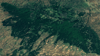
Mau Forest Narok section.
|Health
Premium
Threatened water towers: Mapping illegal logging in Kenya's forest reserves

Kenya's president, William Ruto, has reintroduced logging after a six-year ban. The move, he says, is aimed at creating jobs and boosting the local economy, but Ruto's decision calls into question Kenya's identity and commitment to tackling climate change.
Environmental activists are still struggling to establish the intent and motivation behind the directive and fear the move could lead to catastrophic damage to Kenya's environment.
However, despite the logging ban in 2018, the Nation discovered massive exploitation of selected Kenyan forest reserves through open-source information. In some cases, we found small-scale logging within the forests.


We chose to focus on incidents where there appeared to be a reasonable amount of open-source evidence and data available. It is important to note that many other sites have been reported.
However, the examples chosen highlight the dangers that face or have been inflicted on, important sites across the country.
Digging into satellite imagery
A 2017 report by the United Nations Environment Programme (UNEP) explained that Kenya loses 70,000 hectares of forest to illegal logging every year.
The report also highlighted that Kenya's weak laws are largely to blame for this predicament.
To paint a helpful picture of the wider environmental conditions around Kenya's famous forests, satellite imagery from Google Earth has served well for remote sensing of major deforestation and logging activities.
Western Mau Forest

A Google map of Western Mau Forest (Below) A contrast of the same area in 2018 (Left) and 2022 (Right).
Media reports from various sources have previously suggested that the Mau Forest Complex is under threat from charcoal burning and illegal logging.
Satellite imagery of the Mau Forest Complex shows that between 2018 and 2022 there will be at least four large-scale logging operations in the Western Mau Forest, which is shared between Kericho and Nakuru Counties.
To demonstrate the damage, a comparison between years can be made to see what has changed in this area.
Mau Forest - Mariashoni area.

Mau Forest - Mariashoni area: A contrast of the same area in 2018 (left) and 2022 (right).
Large-scale destruction of the Mau Forest within Nakuru. In particular, the valley at Marashoni has experienced widespread deforestation over the last 5 years, as seen on Maxar Satellite imagery.
In the satellite images, the area is the same, but in time they are completely different. Vast areas of deforestation and new agricultural land indicate encroachment.

Mau Forest - Nakuru County 2018 and 2019.
An earlier report by the Kenya Forest Service highlighted that human encroachment remains a challenge to the Eastern Mau ecosystem. Analysis of the map revealed a startling detail that underscores this in the Mariashoni area of Nakuru County.
By taking a chronological view of this mapped area, Nation found that some 12 square kilometres of forest cover had been almost entirely replaced by farmland.

Mau Forest Kedowa section.
To account for the different dates of available satellite imagery - and to further establish changes over the years - we looked at Wayback satellite imagery for a clear contrast. We found huge changes between 2018 and 2022.
Recent satellite images of the Mariashoni area have patterns of farms, so we do not see the spontaneous green forest that was visible in 2018. It is clear that the forest cover has been replaced by bare farms. A closer look reveals more of these distinctive markings.
Bugar Forest

A contrast of Bugar Forest, Elgeyo Marakwet County, in 2018 and 2022.
Bugar Forest, in Elgeyo Marakwet County, also shows evidence of more farmland that was once dense forest. Correlating this with a wayback machine since 2018, satellite imagery shows that this area had a dense forest cover that has now been encroached into.
Kinale Forest.

Satellite view of Kinale Forest - Muranga section. (Top) A contrast of the same area in 2018 and 2022. Bottom: Satellite imagery showing small-scale illegal logging.
In a section of Kinale Forest in Murang'a District, it is very easy to see where trees have been cleared and replaced with farms. Similarly, a closer look at the contrast of the images in the Google Earth Wayback Machine images gives a clearer picture of the small-scale destruction within the forest.
Kakamega Forest

Kakamega Forest: A contrast of the same area in 2018 (left) and 2022 (right).
In a section of Kakamega Forest between Vihiga and Nandi counties, our analysis found a significant decrease in vegetation in the southern section between 2018 and 2022.
While it is not yet clear what the government's methodology will be for deciding which trees can be felled, conservationists say that lifting the ban would make it difficult to monitor the environmental impact of the move.
Kenya's forest reserves are undoubtedly the source of many of the rivers that supply water to millions of Kenyans. Illegal logging is already threatening the water supply. This is likely to get worse.