300,000 lives at risk as State officials dump crucial report on safety of dams
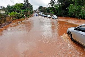
Graves partly submerged by the swellling Lake Turkana at Leyani in Loiyangalani, Marsabit County, on October 21.

What you need to know:
- Kenya currently has 4,100 dams and water pans distributed throughout the country.
- The major dams include the Seven Folks Dams that are used for production of electricity, Sasumua and Ndakaini dams that are the main water sources for Nairobi.
- Additional 57 dams and pans are being implemented.
The government did little about its critical report showing the lack of framework for disaster preparedness response for dams, and now officials are racing against time to find ways of saving 300,000 people facing imminent danger of the spillage of the Turkwel hydropower dam.
The Dams Report released in August 2019 by a 15 member taskforce commissioned by the Ministry of Water had expressed concerns that the status of dams in the country were not being inspected since no authority is expressly mandated by law to do so.
Kenya currently has 4,100 dams and water pans distributed throughout the country. The major dams include the Seven Folks Dams that are used for production of electricity, Sasumua and Ndakaini dams that are the main water sources for Nairobi. Additional 57 dams and pans are being implemented.


The report also found that there was involvement of quacks and poor assessment of contractors and project sites by the indirectly responsible government agencies.
The grievousness of their writings is playing out currently with Turkwel, situated in West Pokot, filling up to only two metres shy of overflowing, which reportedly could happen any minute.
Disaster preparedness
Officials of the National and county governments of Turkana and West Pokot cannot trace the contingency plan used in the construction to guide disaster preparedness and secure the population.
Turkana Governor Josephat Nanok on Monday told reporters that they were not ready and did not know how to manage the situation.
“Are we ready? No. We don't know where the contingency plan used construct the dam is. We’re waiting on the National government to guide on that,” said Mr Nanok during a visit to the site.
He was accompanied by his West Pokot counterpart John Lonyangapuo and the Water Resources Authority (WRA) Chief Executive Officer Mohammed Shurie.
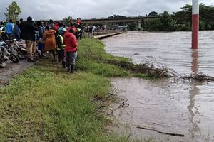
The areas in danger include Katilu, Lodwar, Kalemnyang, Loyapat, Nakwamoru, and other settlements along the shores of Lake Turkana.
The 35-year-old dam has never overflowed before, but is now about 92 per cent full with a water level of 8.48 meters higher as of five days ago, leaving only 2.28 meters before spilling.
"Water abstraction points such as River Turkwel Irrigation Scheme and bridges along the river might be damaged," Mr Shurie said, and urged residents living in areas likely to be affected by the floods to move to higher grounds.
He attributed the high water levels to rains that have been occurring in the area since October 2019. The dam's capacity is 1.6 billion metric tons and sits on 6,500 hectares with a hydraulic head of 150M.
Prof Bernard Rop, a geology lecturer at Jomo Kenyatta University of Agriculture and Technology, says that the water levels in the great East African Rift lakes are rising due to complex geological and hydrological factors.
“Apart from earth's movements caused by rifting and drifting, flooding in the Rift Valley is caused by the rapid inherent global ecological and climatic changes experienced and enhanced by human activities like land-use,” he said.
Other contributing factors affecting the rising levels of the water have commonly been attributed to increased rainfall, siltation and pressure on land.
The Kenya Red Cross Society is part of a multi-agency Turkwel dam monitoring team formed to oversee the situation.
Rising levels of water
“We have been monitoring rising levels of water in Turkwel dam in West Pokot County, indications are that the dam is likely to overflow around the end of October or first week of November,” said the agency in a statement, and advised people living in risky areas to relocate to safe grounds.
The lack of preparedness shows laxity on the part of the government considering that a warning of impending overflow had been given in July by the Kerio Valley Development Authority (KVDA).
Managing Director Sammy Naporos had then announced the levels were 1,142 metres and seven metres high of spilling.
In last year’s report, the government taskforce enquired, investigated and assessed the status of the dams in the country with a focus on policy legal and regulatory frameworks, safety and operations and the ability of the agencies to deliver on their mandate.
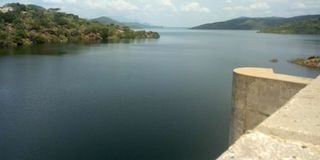
Turkwel dam in West Pokot. The dam is expected to spill over in the coming two weeks following heavy rains.
“In our assessment of the laws, we find that dam safety not assigned to any government regulator and therefore a majority of the dams have gone for decades without inspection,” said the taskforce chairman Samuel Alima during the launch attended by former Water Cabinet Secretary Simon Chelugui.
He gave an example of Kesses dam in Eldoret whose ownership is unknown.
Mr Chelugui, now heading the Ministry of Social Services, had said the collapse of Solai dam in 2018 that killed 48 people, caused the ministry to have an introspective assessment of the status of the rest across the country.
Following the catastrophe, Water ministry raised a concern that dams were largely unsafe due to lack of constant inspection, with some silted up, spillways clogged in others with the rest having weak embankment or internal core material eroded leading to seepages. Although names of the dams were held back, it’s clear that great danger lurks.
The report found that there were no clear guidelines on issuance of permits as many institutions engaged in it.
According to law, Water Management Authority is responsible for authorisation to construct the dam and issuance of permit to abstract water.
National Environmental Management Authority (Nema), National Construction Authority, department of Physical Planning, Kenya Forest Service and Kenya Wildlife Service are others involved in the licensing process.
The report rated as “fair” the performance of the two ministries for water and environment in executing their role and called for enhancement of the institutional capacity of WRA and Nema to discharge their duties.
Sh440 million is required to implement the recommendations of the report.
In the history of the country, Solai dam was the third dam to have failed. The spill way for Sasumua dam failed in 2003 but without casualties. In 1980s, the Country recorded the first failure when a dam failed in the coffee plantation in Kiambu and it is not clear whether there were casualties.
World over, the South Fork Dam on L. Conemaugh was the first to fail in 1889 killing 2,209 people. Its failure was due to hydrological over-topping.Another failure that claimed 450 people was St. Francis dam in California which happened in 1928.