The wonders of Mwaluganje Elephant Sanctuary
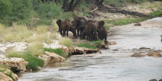
Elephant family by Tsavo bridge on Tsavo River. PHOTO|RUPI MANGAT
What you need to know:
Summary:
- The sanctuary is part of the bigger Mwaluganje-Shimba hills forest and a global biodiversity hotspot
- There are some 500 elephants, mostly the realm of bulls
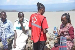
A massive cloud of locusts bursts over Machakos soon after passing the Kyumbi Makutano junction on the Nairobi-Mombasa Highway where the statue of Paul Ngei, the Kamba freedom fighter stands. Everybody is taken by surprise by the flying insects that have been devastating the country since last year, the worst in 70 years, threatening the food security of millions of people.
We’re driving from Nairobi to Mwaluganje Elephant Sanctuary and onward to the coast. We’ve taken the Wote road from Machakos to avoid the truckers’ road that is the main highway. The winding stretch through the many hills between Machakos and Wote is scenic with the terraced farms of the waKamba. It’s hard to imagine that this region was so full of black rhinos until the 1950s before they were got rid of to make way for settlement.
Our next big surprise is miles away. We spot a herd of elephants in Tsavo River flowing below the Nairobi-Mombasa highway. A side track leads us below the road.


Statue in Machakos of Paul Ngei, Kenya's freedom fighter. PHOTO|RUPI MANGAT
The family of tuskers is outside the protected area between the two great Tsavos. A lone bull sucks in water with his trunk to quench his thirst before stepping into the river. He’s probably old enough to leave the female herd to find the other bulls.
Meanwhile above, there’s non-stop traffic of heavy trucks and the occasional train on the standard gauge railway. This is one of the few openings left for the great pachyderms to migrate between the parks and beyond in their eternal search for fresh pastures instead of turning the land bare.
Three hours later we’ve turned into Samburu and onto Mwaluganje, the elephant sanctuary that was opened in 1995 after 200 local Duruma and Digo families set aside land for the pachyderms to move between Tsavo East and Shimba Hills, making Mwaluganje Kenya’s premier community-owned wildlife sanctuary.
The road is rough. We almost miss the main sign to the sanctuary.
On one side of the murram road are the homestead of the Duruma and Digo. They are two of the nine tribes of the Mijikenda people who were forced to flee from their homeland in the horn of Africa around the 9th century, persecuted by the Galla. The found solace in the forests along the coastal strip in today’s Kenya and settled in them setting aside sacred forests called kayas that today harbour fascinating plants and wildlife – like in Mwaluganje and neighbouring Shimba Hills.

Petrified wood in Mwaluganje Elephant Sanctuary. PHOTO|RUPI MANGAT
A side track leads into the sanctuary. It’s late afternoon and we stop for a picnic. The difference is stark between the forested sanctuary and the cleared fields of red clay huts and shrivelled crops.
The sanctuary is stunning. We’re in the midst of high ridges and valleys. Ancient baobabs so fat of girth shows they have been sentinel for a thousand years while the cycads speak of a time before the dinosaurs 65 million years ago. Red-earth rocks gleam on the hills that are petrified wood from a forest of 200 million years ago.
“We have 40 leopards but it could be the lion that’s been recently sighted,” tells ranger Fatuma. “We don’t know where it’s come from because lions were taken out of Shimba hills many years ago to protect the Sable antelopes.”
It’s a mystery to be solved.
More on Mwaluganje
The 36-square-kilometer sanctuary is part of the bigger Mwaluganje-Shimba hills forest and a global biodiversity hotspot. There are some 500 elephants, mostly the realm of bulls.
Hotspots to see:
- The sacred Kitzanze Waterfall which pours into the Manolo River below.
- The Pemba River: The source of the Manolo River that flows from Port Reitz, Mombasa.
- A natural rock bridge (Daraja ya Mungu – God’s bridge) crosses over the Manolo River where elephants and other animals come to drink. In days of old, people sharpened knives on the black stones.
- Jiwe La Saa: A white cliff face near Daraja ya Mungu. It’s the rock that tells time, changing from green in the morning to red in the evening.
- Kaya Mtae: A sacred Duruma forest at the top of Mwaluganje Hill. It’s still used by Duruma elders for prayers in hardship times.
From Mombasa it’s 45 km. From Nairobi, 450km. You can camp or check in at Sable bandas (or camp) in neighbouring Shimba Hills national reserve.