New technique to boost wildlife protection efforts
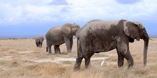
Elephants at Amboseli National Park.
What you need to know:
- The technique uses very high resolution satellite imaging and deep learning machines to monitor the wildlife.
- The new method is able to count elephants in mixed ecosystems such as savannah grasslands and forests.
- The technology will also make tracking of smaller wildlife species much easier.
Researchers have developed a faster technique to remotely survey elephants and other wildlife.
Said to have the same accuracy as human counts done on the ground, the technique uses very high resolution satellite imaging and deep learning machines to monitor the wildlife.
Currently, on-the-ground or airplane surveys are being used in monitoring the wild games, but it is proving quite expensive and time consuming.
Scientists at the universities of Bath and Oxford, who led the research, developed the technique by creating a computer algorithm to analyse satellite images and detect African elephants in grasslands and forests. The population of African elephants have been rapidly declining over the years due to poaching, retaliatory killing from crop raiding and habitat fragmentation.
Presently, there are just about 50,000 left in the African wild.
Misunderstand trends
The researchers say the existing survey techniques for elephant population, mainly aerial counts from manned aircraft, is prone to miscounting.
The researchers, in the journal Remote Sensing in Ecology and Conservation, said inaccurate counts can result in misallocation of scarce conservation resources and misunderstanding population trends.
Olga Isupova, a computer scientists at the University of Bath who co-authored the research, says accurate monitoring is essential in saving the species from extinction. “We need to know where the animals are and how many they are,” says Prof Isupova.
While satellites can collect over 1,900 square miles of imagery every few seconds, they also eliminate the risk of double counting while speeding up the survey from weeks to just a few days.
Using satellites also cuts down on the logistics of monitoring species population that cross international borders. Due to technological advancements, scientist had in the recent past developed ways of monitoring wildlife populations using satellite images, unfortunately they were limited to homogenous habitats, for instance tracking whales in the open ocean.
The new method is, however, able to count elephants in mixed ecosystems such as savannah grasslands and forests where trees would have made satellite tracking difficult.
The scientists further argue that the technology will also make tracking of smaller wildlife species much easier. “Satellite imagery resolution increases every couple of years, and with every increase we will be able to see smaller thing in greater details,” noted Prof Isupova.