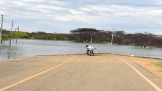
A submerged Loruk-Marigat road that has been swallowed up by Lake Baringo.
| Cheboite Kigen | Nation Media GroupCounties
Premium
Experts: Why the water levels of Rift Valley lakes are rising

What you need to know:
- The affected lakes include Turkana in the north, which is overflowing, and Magadi in the South, which is drying up.
Geologist, Silas Simiyu, says pressure from the Rift’s volcanic system has resulted in water getting into faults, lubricating tectonic plates and causing tremors.
Whatever is happening underneath the Rift Valley has continued to intrigue scientists eager to understand why some of its lakes are overflowing while others are drying up .
While no scientific study has yet been published explaining the recent increase in water levels, there has been no doubt that an activity deep into the earth’s crust could be triggering this overflow aided, perhaps partially, by human activities.


The affected lakes include Turkana in the north, which is overflowing, and Magadi in the South, which is drying up. The unprecedented increase in water levels has also been witnessed in the freshwater lakes of Naivasha and Baringo and the saline lakes of Elmentaita, Nakuru, Bogoria and Logipi.
Just what is happening?
Geologist John Lagat attributes the phenomenon to tectonic activities in the earth’s crust which he claims have affected the Kenyan Tertiary Rift lakes of Baringo, Bogoria and Nakuru and also the Nyanzian Rift where Lake Victoria waters are rising.
Previous geological studies in the Rift Valley have indicated that the lakes have always been victims of underground activities which have led to their rise or shrinking.
Direct impact
Mr Lagat explains that these tectonic activities have a direct impact on the underground permeability, and that this has effects on the subterranean outflow and ground water table.
“Tectonic activity refers to the crustal deformation and reorganisation of the plate tectonics. Most of the lakes in the rift outflow by subterranean (underground) discharge and, if compression stress is induced in the rifting environment, it results to low permeability and the subsurface outflow of water is reduced,” Mr Lagat explains.

A submerged building at the Soi Safari Lodge near Lake Baringo in Baringo County.
In layman’s language, tectonic activity may squeeze the cracks between the tectonic plates, interfering with the lake’s natural underground discharge and forcing the water up, leading to an overflow.
When the reverse happens (widened cracks), the geologist says, the water drains underground at a high rate and the lakes start to dry up. For instance, in 1921, Lake Naivasha waters drained underground and it was reduced to a diameter of one kilometre. Whether that explains the reason why Lake Magadi in Kajiado County and Lake Kamnarok in West Pokot County are drying up is not yet known. But some scientists attribute it, though with no recent research backing it, to “massive siltation”.

A marooned Manyatta at Kalokol in Turkana County.
When the Nation toured the lakes, we came face to face with the worrying destruction of homes, schools, farmlands, grazing lands, hospitals, tourist hotels, roads and other infrastructure.
All these sit on top of a land whose belly boils with maddening geological activities.
The Rift Valley and its lakes were formed millions of years ago following the violent separation of two of the earth’s continental plates floating on the molten magma of the earth’s core. Scientists believe that the sides are still moving apart very slowly and subtly, explaining the existence of volcanoes, mountains and escarpments. Some attribute the new shifts to climate change and siltation.
Simon Onywele, an associate professor at Kenyatta University’s department of environmental planning and management, says the warming of the Indian Ocean’s dipole, which he linked to higher-than-average rainfall during the East African Short Rains (EASR) between October and December, plays a major role in the phenomenon.
The Indian Ocean dipole is the difference in sea-surface temperatures in opposite parts of the ocean. Temperatures in the eastern part of the ocean oscillate between warm and cold compared with the western part.
Warmer temperatures
This year, the dipole has been undergoing a phase that has led to warmer sea temperatures in the western Indian Ocean region, with the opposite in the east, and this contributed to the higher-than-average rainfall and floods in eastern Africa and droughts in south-east Asia and Australia.
“This is why we have read several reports of fires in Australia (with) a heat wave caused by the Indian Ocean dipole providing ample fuel for the fires to grow and spread,” Prof Onywere said.
A 2019 report by the Kenya Meteorological Department says that the country recorded its highest ever short rain season for October-November-December in over 23 years. The previous highest recordings were in 1961 and 1997. Kenya’s October to December 2019 rains were the highest on record for decades. These were followed by above-average rains in 2020. In some areas, they were 400 percent more than normal.

A crocodile basking in the sun near on a rock at Lake Baringo on December 9, 2020.
The phenomenon prompted the Ministry of Environment to commission a task force to look into the reasons behind the rising lakes and give recommendations for action. Environment Cabinet Secretary Keriako Tobiko presented a report to the National Assembly that is yet to be made public. Prof Onywere also believes that massive siltation could be the other reason.
“All rivers that feed the lakes bring in sediments. Intensified and irresponsible land use has resulted in degradation and thus, higher rainfall runoff from land, and less percolation of it into the groundwater systems, leading to larger volumes of water flowing directly and rapidly from the land surface into the lakes,” he says.
He explains that water seepage into underground aquifers has been hampered by silt that clog fault lines and that there has been increased water supply due to increased runoff brought about by land degradation.
Another geologist, Silas Simiyu, says pressure from the Rift’s volcanic system has resulted in water getting into faults, lubricating tectonic plates and causing tremors.
This has been reported in parts of Baringo and West Pokot counties. The three scientists agree that, since the lakes lie in the Rift floor, their water cycles are governed by rainfall on highland catchment areas, which,they say, have recently been receiving above-average rainfall.

Houses submerged at the Lake Bogoria Game Reserve.
While scientists seem to agree that the proportion of rain and sediment that runs off from the catchments is increasing because of the riparian zone encroachment, loss of wetlands, and urban growth, there is no explanation why a lake such as Turkana has defied previous fears that it would dry up as a result of construction of the Omo River dam to the north.
Against all odds, Lake Turkana has risen by up to 12 percent against scientists’ projections last year that the construction of the Gilgel Gibe III Dam in Ethiopia would lower the levels by 2-10 meters (6-33 feet) and increase salinity by more than 50 percent.
Today, at least 30,186 people living on the shores of the lake have been displaced in Kerio, Kangatotha, Kalokol and Lake Zone wards.
At the fishing village of Kalokol, hundreds of Manyattas that served as homes to the fishing community have been swallowed up by the waters.
The expansion of Lake Baringo has also been intriguing after displacing the Njemps community grounds by expanding from 217.26 square-kilometres in 2014 and to the current 264.14 square kilometres. The scenic Ol Kokwe Island, which used to be at the centre of the lake, is now partially submerged and gone are members of the Njemps community, who inhabited the area around the lake, as are the attractive hot springs, boiling mud pools, and fumaroles.
The same fate has also befallen Bogoria, another endhoreic soda lake known for its hot springs. Today, the waters have risen by almost 10 percent in surface area, displacing families, inundating hospitals, business premises and schools and eating away some 360 hectares.
The entrance to the Lake Bogoria National Park at Loboi is completely submerged and the entire Maji Ndege village is no more. Previously, River Mpirrich used to flow to Lake Bogoria from Ilemane swamp. Today, water is flowing from Lake Bogoria, which has risen by 26 percent, back to the swamp by the same river!
Lake Nakuru was the first of the Rift Valley lakes to burst its banks. The lake increased its area from 3,269 hectares in January 2010 to a high of 5,400 hectares in October 2020, swallowing its entry gates, driveways and pushing its borders to private lands.
The same was witnessed in Lake Naivasha, which previously occupied a total area of 112.66 square-kilometres in 2010 to the current 173 square-kilometres.
As geologist grapple with this scientific headache, they Rift Valley lakes appear to be reclaiming territories they had lost millions of years ago. How far they will extend is not known.