Need a place to get clean air? Your phone will soon do the dirty work
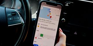
A Google map application displaying Covid-19 restrictions along your route on a smartphone in Arlington, Virginia on June 9, 2020.

Imagine a voice from your phone advising you which roads or paths have cleaner air than others after analysing the concentration of smoke, dust, carbon dioxide and other air pollutants for you.
Imagine technology that can help you decide which routes to use, and which can end up driving production plants out of the traditional modes of relying on fossil fuels that pump dirty air into roads.
Imagine no more, because, in the effort to reduce global carbon footprints, you will soon start enjoying the thrill of fresher air across Kenya’s major towns, thanks to new updates on Google Maps.


Using Artificial Intelligence algorithms that run on geolocation data on your smartphone, Google is incorporating artificial sensors to determine the humidity, air pressure and impurity level of the air you are breathing, in real-time.
You will therefore see air quality layers on your Google Maps app starting this September, telling you how clean or dirty the oxygen in your destination is.
The updates also come with weather prediction aided by predictive data analytics technology, and Google will now be alerting you whether the place you are heading to will rain or remain sunny.
“With the new weather layer, you can quickly see current and forecast temperature and weather conditions in an area, so you’ll never get caught in the rain without an umbrella,” Dane Glasgow, vice president of product at Google Maps, told the Saturday Nation.
Quality layer information
The new air quality layer information could prove helpful for users who have allergies, or are in a smoggy, tear-gassed or fire-prone area.
Google said data from partners like The Weather Company, AirNow and the US Central Pollution Board will power the layers on Android and Apple smartphones.
The company is also set to map urban centres according to levels of carbon emission, and advising motorists to avoid high emission zones on the go. Drivers will also be notified when a high emission vehicle is approaching or nearby.
Google Maps, an essential service that has revolutionised transport and logistics in Kenya, birthing a new sub-sector of food delivery through services like Uber Eats, Sendy and Glovo, has also come with real-time recommendations on routes that consume lower fuel.
“We are building a new routing model that optimises for lower fuel consumption based on factors like road incline and traffic congestion,” said Anita Yuen, director of product at Google Maps.
Users can expect a comprehensive view of all routes and levels of greenhouse emissions to their destination, allowing them to compare how long it’ll take to get there by car, transit or bike without toggling between tabs.
Carbon dioxide emissions
In cases where the eco-friendly route could significantly delay your estimated time of arrival, Google said it will let motorists compare the relative carbon dioxide emissions among routes for them to decide the best one.
The company said since February 2020, it had recorded more than 55 per cent increase in usage of Google Maps features in Kenya, where more than 12 million people own smartphones, according to a 2019 study by the International Data Corporation (IDC).
Data from the World Health Organisation (WHO) shows that nine out of 10 people breathe air containing high levels of pollutants. About seven million people die every year of ambient and household air pollution globally.
“Air pollution threatens us all, but the poorest and most marginalised people bear the brunt of the burden,” says Dr Tedros Adhanom, Director-General of WHO.
The health agency estimates that over three billion people, most of them women and children, are still breathing deadly smoke every day from using polluting stoves and fuels in their homes.
“If we don’t take urgent action on air pollution, we will never come close to achieving sustainable development,” he warns.
The air pollutants of primary concern in urban settings include sulfur dioxide, nitrogen dioxide and carbon monoxide, which are emitted directly into the air from fossil fuels such as diesel, petrol, kerosene, gasoline, and natural gas, all which are burned in power plants, automobiles and combustion tubes.
Heart disease
The WHO says polluted air penetrates deep into the lungs and the cardiovascular system, causing ailments like stroke, heart disease, lung cancer, chronic obstructive pulmonary diseases and respiratory infections, including pneumonia.
It also reveals that air pollution is a critical risk factor for non-communicable diseases, causing an estimated one-quarter of all adult deaths from heart disease, another quarter from stroke, 43 per cent from chronic obstructive pulmonary disease and 29 per cent from lung cancer.
More than 90 per cent of air pollution-related deaths occur in low income countries, mainly in Asia and Africa, the WHO says.
Major sources of air pollution from particulate matter include the inefficient use of energy by households, industry, the agriculture and transport sectors, and coal-fired power plants.
In some regions, sand and desert dust, waste burning and deforestation are additional sources of air pollution. Air quality can also be influenced by natural elements such as geographic, meteorological and seasonal factors.