Maps the new battlefront in the fight for forest land
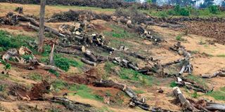
Felled indigenous tress in Maasai Mau Forest, Narok County.

What you need to know:
- The loss of powers by Kenya Forest Service to sanction variation of forest boundaries gives leeway to politicians to tinker with them.
- The government need to secure the legal boundaries of forest reserves, ensure that forest boundaries are well marked on the ground.
In the last two decades of the 20th Century, two developments had a deleterious effect on Kenya’s forest cover. First was the creation of the Nyayo Tea Zones (NTZ) in 1986. Established in the high potential forest areas of Mount Kenya, Aberdare Ranges, Mau/Trans-Mara and Ol-Posumoru Forest Complex, Nandi Forest, Kakamega Forest, Mt Elgon and Cherangani Hills and Kaptagat forests, they are inside the perimeters of gazetted forest reserves.
Secondly, due to economic downturn and the freezing of foreign aid in the early 1990s, politicians sought alternative patronage resource by manipulating land rights to reward supporters (through allocation of public land, including forests) and punish opponents (via land-related election violence).
The “Presidential Commission of Inquiry into the Illegal/Irregular Allocation of Public Land Report 2004” (‘Ndung’u report’) revealed that most allocations of forest land were made to individuals, schools, Agricultural Society of Kenya (ASK) and NTZ for a variety of purposes, with the last one a “conduit through which forestland was illegally allocated”.


And “while the [Nyayo Tea] Zones were meant to extend up to 100-metre strip of tea belt around forests in the tea-growing areas, extra acreages were hived under the guise of [Nyayo] Tea Zones and later allocated to individuals”.
Forest boundaries
The case of Mau Forest Complex, which comprises seven blocks, is disturbing, as shown by Erick F. N. Akotsi, Michael Gachanja and Jacob K. Ndirangu in Changes in forest cover in Kenya’s five water towers), Marion Mutugi and Winfred Kiiru (Biodiversity, local resource, national heritage, regional concern, and global impact: The case of Mau Forest, Kenya) and Stefania Albertazzi, Valerio Bini, Adrien Lindon and Guido Trivellini (Relations of power driving tropical deforestation: A case study from the Mau Forest).
Most Kenyan forests have receded drastically over time but Maasai Mau Forest, being ungazetted trust land, is the most affected — as shown in the 1986 ‘Ntutu commission’ on boundary review of the Maasai Mau Forest and the 2009 report of the task force on the conservation of the Mau Forest Complex.
Jacqueline M. Klopp and Job Kipkosgei Sang (Maps, Power, and the Destruction of the Mau Forest in Kenya) says “the Mau Forest struggle is the question of who creates and controls forest data, particularly maps” ; its boundaries determine “who must leave and who can stay”. The struggle over reforestation is “linked not only to social and economic forces but to politics, patronage and the power of maps as well”.
The loss of powers by Kenya Forest Service to sanction variation of forest boundaries, as proposed in the Forest Conservation and Management (Amendment) Bill 2021, gives leeway to politicians to tinker with them. Petitions to Parliament could include regularising title to land in forests and allocation of forest land. The Bill may have targeted beneficiaries.
The government need to secure the legal boundaries of forest reserves, ensure that forest boundaries are well marked on the ground, survey and gazette Maasai Mau trust as a forest entity and issue title deeds for protected areas. As per the Ndung’u report, “Nyayo Tea Zones should be abolished” and the lands “revert to forest land” and any titles acquired by individuals for such land revoked.
Mr Mukui is a consultant economist. [email protected]